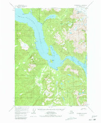
1955 Map of Petersburg B-1
USGS Topo · Published 1979About this map
Wrangell Island and the surrounding Alexander Archipelago waterways are documented here as they appeared in the mid-1950s, highlighting the region's reliance on maritime and natural resources. This coastal landscape is dominated by the intersection of Eastern Passage and Blake Channel, where tidal flats and steep mountains meet the sea. Historical activity is concentrated near the water, with a Sawmill and several cabins located along the shoreline near the mouth of Mill Creek. To the east, the terrain rises sharply toward Marsha Peak and the Nelson Glacier, illustrating the proximity of glacial ice to the coastal timber and fishing grounds. The survey captures a moment when isolated cabins and small-scale operations like the Mine near The Narrows were the primary markers of human presence within the Tongass National Forest.
Find a feature on this map
45 named features on this map. Tap any name to fly to it.
Don’t see what you’re looking for? This feature index may not catch every label — zoom into the map to look around manually.
Map Details
Editions of this 1955 Petersburg B-1 Map
2 editions found

Other maps of this area

1948 · Petersburg A-1
USGS Topo · 1:63,360

1948 · Petersburg A-2
USGS Topo · 1:63,360

1948 · Petersburg C-1
USGS Topo · 1:63,360

1948 · Petersburg C-2
USGS Topo · 1:63,360

1948 · Petersburg B-2
USGS Topo · 1:63,360

1948 · Petersburg B-1
USGS Topo · 1:63,360

1951 · Bradfield Canal
USGS Topo · 1:250,000

1951 · Petersburg C-2
USGS Topo · 1:63,360

1951 · Petersburg A-1
USGS Topo · 1:63,360

1952 · Petersburg
USGS Topo · 1:250,000