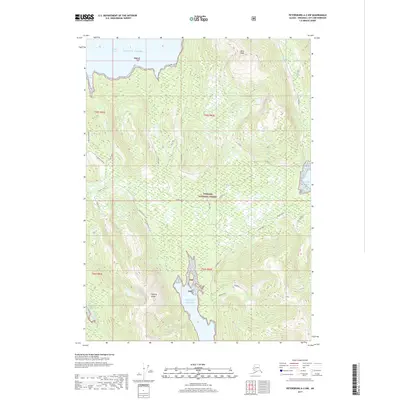
2017 Map of Petersburg A-2 NW
USGS Topo · Published 2017About this map
The coastal environment of the Alexander Archipelago characterizes the Petersburg A-2 NW region in 2017. Situated within the Tongass National Forest, this area borders the Gulf of Alaska and is defined by intricate waterways and steep elevations. Marine features such as Kindergarten Bay, Quiet Harbor, and Steamer Bay carve into the land, while the Stikine Strait provides a major passage for vessels. Inland, the Keating Range and peaks like Alice Peak dominate the topography, accompanied by descriptive landmarks like Snow Ridge and Cedar Cliff. The presence of Mosman Inlet and E Mosman Inlet illustrates the deep inlets common to the area. From the uniquely named Almost Quiet to infrastructure markers like W Sortyard and Lake Spur, these labels provide specific coordinates for those exploring this Alaskan wilderness.
Find a feature on this map
31 named features on this map. Tap any name to fly to it.
Don’t see what you’re looking for? This feature index may not catch every label — zoom into the map to look around manually.
Map Details
Editions of this 2017 Petersburg A-2 NW Map
This is the sole edition of this map. No revisions or reprints were ever made.
Other maps of this area

1948 · Petersburg A-2
USGS Topo · 1:63,360

1948 · Petersburg B-2
USGS Topo · 1:63,360

1948 · Petersburg B-3
USGS Topo · 1:63,360

1949 · Petersburg A-3
USGS Topo · 1:63,360

1951 · Petersburg B-3
USGS Topo · 1:63,360

1952 · Petersburg
USGS Topo · 1:250,000

1953 · Petersburg A-3
USGS Topo · 1:63,360

1953 · Petersburg A-2
USGS Topo · 1:63,360

1953 · Petersburg B-2
USGS Topo · 1:63,360

1960 · Petersburg
USGS Topo · 1:250,000