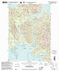
1995 Map of Petersburg A-2
USGS Topo · Published 1999About this map
Etolin Island dominates this mid-1990s landscape, where the Tongass National Forest meets the intricate waterways of Southeast Alaska. The map illustrates a resource-driven economy, featuring a Logging Camp and Log Transfer Facility situated on Anita Bay, alongside private aquaculture ventures like the Oyster Farm near Mosman Island. The southern reaches are defined by the South Etolin Wilderness, a protected expanse that includes peaks such as Navy Peak and the remote Jadski Cove.
Find a feature on this map
82 named features on this map. Tap any name to fly to it.
Don’t see what you’re looking for? This feature index may not catch every label — zoom into the map to look around manually.
Map Details
Editions of this 1995 Petersburg A-2 Map
This is the sole edition of this map. No revisions or reprints were ever made.
Other maps of this area

1948 · Petersburg A-1
USGS Topo · 1:63,360

1948 · Petersburg A-2
USGS Topo · 1:63,360

1948 · Petersburg B-2
USGS Topo · 1:63,360

1948 · Petersburg B-1
USGS Topo · 1:63,360

1948 · Petersburg B-3
USGS Topo · 1:63,360

1949 · Craig D-3
USGS Topo · 1:63,360

1949 · Craig D-2
USGS Topo · 1:63,360

1949 · Petersburg A-3
USGS Topo · 1:63,360

1949 · Craig D-1
USGS Topo · 1:63,360

1950 · Craig D-3
USGS Topo · 1:63,360