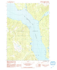
1992 Map of Petersburg B-1 NW
USGS Topo · Published 1992About this map
Wrangell Island dominates the western portion of this 1990s survey, separated from the mainland by the deep waters of Eastern Passage. The map documents a rugged coastal landscape where steep topography meets complex tidal environments, particularly notable at Crittenden Creek and the extensive Tidal Flats around Babbler Point. The mainland side is characterized by significant freshwater bodies like Virginia Lake, which feeds into the passage via Mill Foot Creek.
Find a feature on this map
19 named features on this map. Tap any name to fly to it.
Don’t see what you’re looking for? This feature index may not catch every label — zoom into the map to look around manually.
Map Details
Editions of this 1992 Petersburg B-1 NW Map
This is the sole edition of this map. No revisions or reprints were ever made.
Other maps of this area

1948 · Petersburg C-1
USGS Topo · 1:63,360

1948 · Petersburg C-2
USGS Topo · 1:63,360

1948 · Petersburg B-2
USGS Topo · 1:63,360

1948 · Petersburg B-1
USGS Topo · 1:63,360

1951 · Petersburg C-2
USGS Topo · 1:63,360

1952 · Petersburg
USGS Topo · 1:250,000

1953 · Petersburg C-1
USGS Topo · 1:63,360

1953 · Petersburg B-2
USGS Topo · 1:63,360

1955 · Petersburg B-1
USGS Topo · 1:63,360

1960 · Petersburg
USGS Topo · 1:250,000