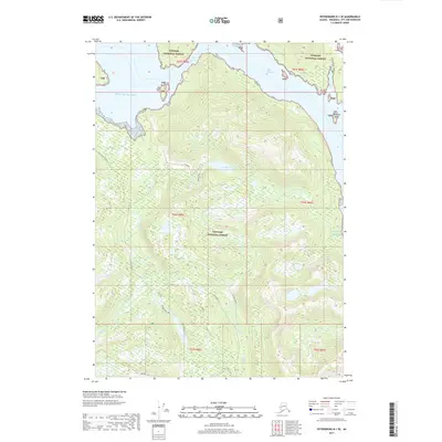
2017 Map of Petersburg B-1 SE
USGS Topo · Published 2017About this map
The Tongass National Forest dominates this coastal Alaskan landscape, where steep maritime slopes meet the intricate waterways of the Alexander Archipelago. This 2017 study illustrates a network of primitive access routes and seasonal drainages, most notably the Long Lake Trail and Aaron Creek Trail, which provide passage through the dense forest towards the interior peaks. The coastline is defined by protected inlets and navigational passages such as The Narrows, Blake Channel, and Berg Bay. High-altitude water bodies like Highbush Lake and Long Lake feed the glacial streams that carve through the wilderness, including Fools Cr and Earl West Cr. The map captures the specialized geography of the region, from the tidewater flats of Earl West Marsh to the isolated Neptune Island, reflecting a landscape primarily managed for conservation and wilderness recreation.
Find a feature on this map
27 named features on this map. Tap any name to fly to it.
Don’t see what you’re looking for? This feature index may not catch every label — zoom into the map to look around manually.
Map Details
Editions of this 2017 Petersburg B-1 SE Map
This is the sole edition of this map. No revisions or reprints were ever made.
Other maps of this area

1948 · Petersburg A-1
USGS Topo · 1:63,360

1948 · Petersburg B-1
USGS Topo · 1:63,360

1951 · Bradfield Canal
USGS Topo · 1:250,000

1951 · Petersburg A-1
USGS Topo · 1:63,360

1952 · Petersburg
USGS Topo · 1:250,000

1954 · Bradfield Canal
USGS Topo · 1:250,000

1955 · Bradfield canal A-6
USGS Topo · 1:63,360

1955 · Bradfield canal B-6
USGS Topo · 1:63,360

1955 · Petersburg B-1
USGS Topo · 1:63,360

1955 · Bradfield Canal
USGS Topo · 1:250,000