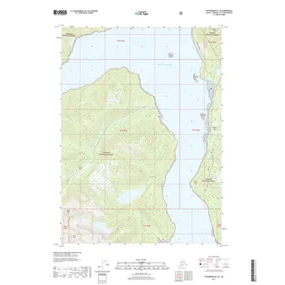
2017 Map of Petersburg B-2 SE
USGS Topo · Published 2017About this map
Zimovia Strait separates the coastal elevations of Wrangell Island from the rugged interior of Etolin Island in this coastal Alaskan study. The landscape is dominated by significant summits, including Chichagof Peak to the north and the high points of Bessie Peak and Helen Peak in the southwest. Transport in the region is concentrated along the shoreline, where the Zimovia Highway follows the narrow coastal strip of Wrangell Island, providing access near Nemo Point. Away from the main road, the Kunk Lake Trail offers a path into the wilderness toward Kunk Lake and its drainage via Kunk Cr. This layout highlights the classic Southeast Alaskan pattern of maritime-dependent development where steep terrain and the Tongass National Forest reach directly to the waters of the Gulf of Alaska.
Find a feature on this map
24 named features on this map. Tap any name to fly to it.
Don’t see what you’re looking for? This feature index may not catch every label — zoom into the map to look around manually.
Map Details
Editions of this 2017 Petersburg B-2 SE Map
This is the sole edition of this map. No revisions or reprints were ever made.
Other maps of this area

1948 · Petersburg A-1
USGS Topo · 1:63,360

1948 · Petersburg A-2
USGS Topo · 1:63,360

1948 · Petersburg B-2
USGS Topo · 1:63,360

1948 · Petersburg B-1
USGS Topo · 1:63,360

1951 · Petersburg A-1
USGS Topo · 1:63,360

1952 · Petersburg
USGS Topo · 1:250,000

1953 · Petersburg A-2
USGS Topo · 1:63,360

1953 · Petersburg B-2
USGS Topo · 1:63,360

1955 · Petersburg B-1
USGS Topo · 1:63,360

1960 · Petersburg
USGS Topo · 1:250,000