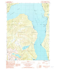
1992 Map of Petersburg B-2 SE
USGS Topo · Published 1992About this map
Etolin Island and Wrangell Island dominate this coastal landscape, separated by the deep waters of Zimovia Strait. This late twentieth-century survey reveals a largely natural terrain within the Tongass National Forest, where high elevations like Bessie Peak and Helen Peak overlook a complex network of tidal flats and waterways. Human infrastructure is concentrated along the eastern shore, where the Zimovia Highway skirts the coast of Wrangell Island, passing near Pats Lake and crossing the Wrangell Corporate Boundary. On the Etolin side, the map documents the interior drainage of Kunk Lake feeding into Kunk Creek. These features illustrate the intersection of maritime navigation through Chichagof Pass and the early road development essential to this Alaskan panhandle community.
Find a feature on this map
15 named features on this map. Tap any name to fly to it.
Don’t see what you’re looking for? This feature index may not catch every label — zoom into the map to look around manually.
Map Details
Editions of this 1992 Petersburg B-2 SE Map
This is the sole edition of this map. No revisions or reprints were ever made.
Other maps of this area

1948 · Petersburg A-1
USGS Topo · 1:63,360

1948 · Petersburg A-2
USGS Topo · 1:63,360

1948 · Petersburg B-2
USGS Topo · 1:63,360

1948 · Petersburg B-1
USGS Topo · 1:63,360

1951 · Petersburg A-1
USGS Topo · 1:63,360

1952 · Petersburg
USGS Topo · 1:250,000

1953 · Petersburg A-2
USGS Topo · 1:63,360

1953 · Petersburg B-2
USGS Topo · 1:63,360

1955 · Petersburg B-1
USGS Topo · 1:63,360

1960 · Petersburg
USGS Topo · 1:250,000