
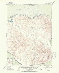
1951 Map of Petersburg B-3
USGS Topo · Published 1954About this map
Zarembo Island dominates this mid-century maritime study of the Alexander Archipelago, where the interior elevations rise to several prominent peaks. The entire landmass is contained within the Tongass National Forest, illustrating a landscape defined by its heavy timber and complex shoreline of bights and harbors. To the north, across the deep waters of Sumner Strait, lies the southern tip of Mitkof I at Pt Howe. The map details the intricate navigation channels of the era, including Snow Passage and the convergence of Clarence Strait and Stikine Strait. Marine features such as St John Harbor and Baht Harbor are meticulously charted alongside coastal landmarks like Craig Point and Boulder Point, providing a primary source for the coastal geography of Southeast Alaska before significant modern development.
Find a feature on this map
28 named features on this map. Tap any name to fly to it.
Don’t see what you’re looking for? This feature index may not catch every label — zoom into the map to look around manually.
Map Details
Editions of this 1951 Petersburg B-3 Map
2 editions found
Other maps of this area

1948 · Petersburg A-2
USGS Topo · 1:63,360

1948 · Petersburg C-4
USGS Topo · 1:63,360

1948 · Petersburg C-2
USGS Topo · 1:63,360

1948 · Petersburg B-2
USGS Topo · 1:63,360

1948 · Petersburg C-3
USGS Topo · 1:63,360

1948 · Petersburg B-3
USGS Topo · 1:63,360

1949 · Petersburg A-3
USGS Topo · 1:63,360

1949 · Petersburg A-4
USGS Topo · 1:63,360

1949 · Petersburg B-4
USGS Topo · 1:63,360

1951 · Petersburg B-4
USGS Topo · 1:63,360