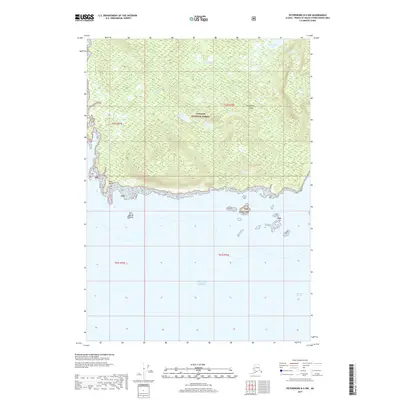
2017 Map of Petersburg B-5 NW
USGS Topo · Published 2017About this map
Kupreanof Island defines the northern half of this coastal area, where the wilderness of the Tongass National Forest meets the open waters of the Gulf of Alaska. The terrain is characterized by a complex network of freshwater systems, including the sizable Kushneahin Lake and the winding Kushneahin Cr, which drains toward the southern coastline. Further west, Barrie Lake sits nestled within the timbered uplands of the TNF boundary.
Find a feature on this map
15 named features on this map. Tap any name to fly to it.
Don’t see what you’re looking for? This feature index may not catch every label — zoom into the map to look around manually.
Map Details
Editions of this 2017 Petersburg B-5 NW Map
This is the sole edition of this map. No revisions or reprints were ever made.
Other maps of this area

1948 · Petersburg B-6
USGS Topo · 1:63,360

1948 · Petersburg C-6
USGS Topo · 1:63,360

1948 · Petersburg C-5
USGS Topo · 1:63,360

1949 · Petersburg B-5
USGS Topo · 1:63,360

1951 · Petersburg C-5
USGS Topo · 1:63,360

1951 · Petersburg B-6
USGS Topo · 1:63,360

1952 · Petersburg
USGS Topo · 1:250,000
1953 · Petersburg B-5
USGS Topo · 1:63,360

1960 · Petersburg
USGS Topo · 1:250,000
1995 · Petersburg B-5
USGS Topo · 1:63,360