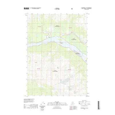
2021 Map of Petersburg C-1 NE
USGS Topo · Published 2021About this map
Chief Shakes Hot Springs serves as a prominent landmark along the Ketili River, where the thermal waters meet the glacial drainages of the Coast Mountains. This modern topographic study reveals a landscape dominated by the winding path of the Stikine River, which carves through the heart of the Tongass National Forest. The complex hydrology of the region is evident in the network of secondary waterways, including Shakes Slough and Shakes Lake in the north, and Andrew Cr and Shaktusa Cr further south. The towering presence of Mt Stinenia anchors the western side of the survey, rising sharply from the river basin. The map illustrates a wilderness defined by its water systems, where the massive river delta and mountain tributaries dictate the shape of the land.
Find a feature on this map
15 named features on this map. Tap any name to fly to it.
Don’t see what you’re looking for? This feature index may not catch every label — zoom into the map to look around manually.
Map Details
Editions of this 2021 Petersburg C-1 NE Map
This is the sole edition of this map. No revisions or reprints were ever made.
Other maps of this area

1948 · Petersburg C-1
USGS Topo · 1:63,360

1951 · Bradfield Canal
USGS Topo · 1:250,000

1952 · Petersburg
USGS Topo · 1:250,000

1953 · Petersburg C-1
USGS Topo · 1:63,360

1954 · Bradfield Canal
USGS Topo · 1:250,000

1955 · Bradfield canal D-6
USGS Topo · 1:63,360

1955 · Bradfield canal C-6
USGS Topo · 1:63,360

1955 · Bradfield Canal
USGS Topo · 1:250,000

1960 · Petersburg
USGS Topo · 1:250,000

1961 · Petersburg D-1
USGS Topo · 1:63,360