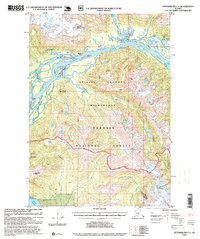
1995 Map of Petersburg C-1
USGS Topo · Published 1999About this map
The Stikine River dominates this landscape, branching into a complex network of sloughs and channels as it flows through the Stikine - LeConte Wilderness. This 1990s revision reveals a land shaped by ice and water, where the Popof Glacier and Nelson Glacier feed into dramatic drainages like Shakes Lake and Andrew Creek. Human presence is marked primarily by recreational and administrative outposts, such as the Shakes Slough Cabins and the Mount Rynda Cabin, reflecting the managed nature of the Tongass National Forest.
Find a feature on this map
44 named features on this map. Tap any name to fly to it.
Don’t see what you’re looking for? This feature index may not catch every label — zoom into the map to look around manually.
Map Details
Editions of this 1995 Petersburg C-1 Map
This is the sole edition of this map. No revisions or reprints were ever made.
Other maps of this area

1948 · Petersburg C-1
USGS Topo · 1:63,360

1948 · Petersburg C-2
USGS Topo · 1:63,360

1948 · Petersburg B-2
USGS Topo · 1:63,360

1948 · Petersburg B-1
USGS Topo · 1:63,360

1951 · Bradfield Canal
USGS Topo · 1:250,000

1951 · Petersburg C-2
USGS Topo · 1:63,360

1952 · Petersburg
USGS Topo · 1:250,000

1953 · Petersburg C-1
USGS Topo · 1:63,360

1953 · Petersburg B-2
USGS Topo · 1:63,360

1954 · Bradfield Canal
USGS Topo · 1:250,000