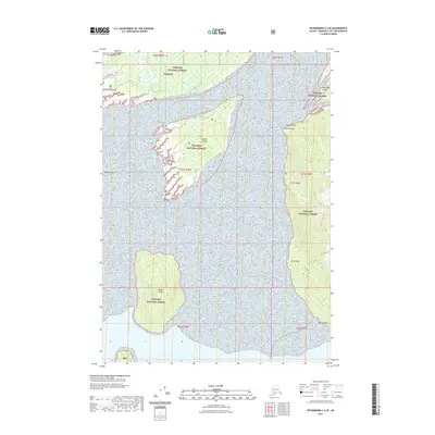
2021 Map of Petersburg C-2 SE
USGS Topo · Published 2021About this map
Wrangell sits at the northern edge of this coastal survey, where the intricate geography of the Alexander Archipelago meets the mainland. This map illustrates the complex tidal environment of the Tongass National Forest, dominated by the silt-heavy expanses of Koknuk Flats and the protective landmasses of Sergief Island and Kadin Island. The topography reveals the interplay of freshwater drainage and saltwater channels, particularly around Binkleys Slough and the Cottonwood Islands. Significant coastal landmarks such as Point Rothsay, Garnet Ledge, and Green Point provide essential navigational reference points along the shoreline. The vast tidal flats and forested slopes shown here reflect the region's enduring reliance on marine transit and natural resource boundaries in Southeast Alaska.
Find a feature on this map
19 named features on this map. Tap any name to fly to it.
Don’t see what you’re looking for? This feature index may not catch every label — zoom into the map to look around manually.
Map Details
Editions of this 2021 Petersburg C-2 SE Map
This is the sole edition of this map. No revisions or reprints were ever made.
Other maps of this area

1948 · Petersburg C-1
USGS Topo · 1:63,360

1948 · Petersburg C-2
USGS Topo · 1:63,360

1948 · Petersburg B-2
USGS Topo · 1:63,360

1948 · Petersburg B-1
USGS Topo · 1:63,360

1951 · Petersburg C-2
USGS Topo · 1:63,360

1952 · Petersburg
USGS Topo · 1:250,000

1953 · Petersburg C-1
USGS Topo · 1:63,360

1953 · Petersburg B-2
USGS Topo · 1:63,360

1955 · Petersburg B-1
USGS Topo · 1:63,360

1960 · Petersburg
USGS Topo · 1:250,000