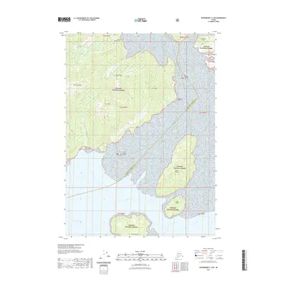
2021 Map of Petersburg C-2 SW
USGS Topo · Published 2021About this map
Mitkof Island dominates this southeastern Alaska landscape, defined by high summits like Manzanita Peak and Sam Peak that rise sharply from the coastline. The Mitkof Highway traces the western shore of the island, following the contours of the Sumner Strait. This area is entirely contained within the Tongass National Forest, illustrating the vast protected wilderness of the Alexander Archipelago. Numerous smaller landforms and tidal islands, including Sokolof Island and the Wilson Islands, dot the surrounding waters of Dry Strait, reflecting a complex marine environment where navigation depends heavily on the shifting geography of the passage. The boundary line running through the straits marks the division between Petersburg Borough and the Wrangell City and Borough, showing the administrative limits within this island-heavy terrain.
Find a feature on this map
22 named features on this map. Tap any name to fly to it.
Don’t see what you’re looking for? This feature index may not catch every label — zoom into the map to look around manually.
Map Details
Editions of this 2021 Petersburg C-2 SW Map
This is the sole edition of this map. No revisions or reprints were ever made.
Other maps of this area

1948 · Petersburg C-2
USGS Topo · 1:63,360

1948 · Petersburg B-2
USGS Topo · 1:63,360

1948 · Petersburg C-3
USGS Topo · 1:63,360

1948 · Petersburg B-3
USGS Topo · 1:63,360

1951 · Petersburg B-3
USGS Topo · 1:63,360

1951 · Petersburg C-2
USGS Topo · 1:63,360

1952 · Petersburg
USGS Topo · 1:250,000

1953 · Petersburg B-2
USGS Topo · 1:63,360

1953 · Petersburg C-3
USGS Topo · 1:63,360

1960 · Petersburg
USGS Topo · 1:250,000