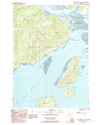
1992 Map of Petersburg C-2 SW
USGS Topo · Published 1992About this map
Mitkof Island serves as the focal point for this Southeast Alaska coastal study, revealing the complex waterways of the Alexander Archipelago. The landscape is defined by the Tongass National Forest and the Stikine-Leconte Wilderness, where tidal flats and sloughs like Knig Slough and Dry Strait create a shifting boundary between land and sea. The Mitkof Highway provides the primary overland connection, leading to the Ernie Haugen Public Use Area and a boat ramp that serves as a critical access point for the region's marine-dependent economy. Surrounding islands, including Rynda Island, Sokolof Island, and Greys Island, are documented alongside various peaks such as Manzanita Peak and Favor Peak. This provisional record highlights the navigational hazards and landmarks essential for local transit through the Sumner Strait during the early 1990s.
Find a feature on this map
23 named features on this map. Tap any name to fly to it.
Don’t see what you’re looking for? This feature index may not catch every label — zoom into the map to look around manually.
Map Details
Editions of this 1992 Petersburg C-2 SW Map
This is the sole edition of this map. No revisions or reprints were ever made.
Other maps of this area

1948 · Petersburg C-2
USGS Topo · 1:63,360

1948 · Petersburg B-2
USGS Topo · 1:63,360

1948 · Petersburg C-3
USGS Topo · 1:63,360

1948 · Petersburg B-3
USGS Topo · 1:63,360

1951 · Petersburg B-3
USGS Topo · 1:63,360

1951 · Petersburg C-2
USGS Topo · 1:63,360

1952 · Petersburg
USGS Topo · 1:250,000

1953 · Petersburg B-2
USGS Topo · 1:63,360

1953 · Petersburg C-3
USGS Topo · 1:63,360

1960 · Petersburg
USGS Topo · 1:250,000