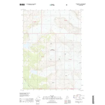
2017 Map of Petersburg D-2 NW
USGS Topo · Published 2017About this map
Patterson Glacier and the high elevations of the Coast Mountains dominate this 2017 study of the Tongass National Forest in Alaska. The landscape is defined by its glacial activity and dramatic vertical relief, with numerous named summits including Church Peak, Saw Peaks, and Rodgers Peak providing fixed points across the ice and rock. In the lower elevations, drainage patterns are established by the Muddy River and N Blind River, which carry meltwater from the high peaks toward the coast. This map documents a largely roadless wilderness, focusing on the natural topography and the immense footprint of the Patterson Glacier during the early 21st century.
Find a feature on this map
18 named features on this map. Tap any name to fly to it.
Don’t see what you’re looking for? This feature index may not catch every label — zoom into the map to look around manually.
Map Details
Editions of this 2017 Petersburg D-2 NW Map
This is the sole edition of this map. No revisions or reprints were ever made.
Other maps of this area

1952 · Petersburg
USGS Topo · 1:250,000

1952 · Sumdum
USGS Topo · 1:250,000

1960 · Petersburg
USGS Topo · 1:250,000

1961 · Sumdum A-2
USGS Topo · 1:63,360

1961 · Petersburg D-3
USGS Topo · 1:63,360

1961 · Sumdum A-3
USGS Topo · 1:63,360

1961 · Petersburg D-2
USGS Topo · 1:63,360

1961 · Sumdum
USGS Topo · 1:250,000

1994 · Petersburg D-2
USGS Topo · 1:63,360
1995 · Petersburg D-3
USGS Topo · 1:63,360