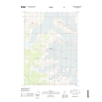
2021 Map of Petersburg D-2 NW
USGS Topo · Published 2021About this map
Tongass National Forest dominates this Alaskan landscape, characterized by dramatic elevation changes within the Coast Mountains. The interior terrain is defined by a series of prominent summits, including Church Peak, Dupont Peak, and the jagged Saw Peaks. Water systems carve through the glacial valleys, with the Patterson River flowing through the northwest and the Muddy River winding through the southern reaches. This modern survey illustrates how topographic features dictate movement in the borough, where the Muddy River Trl and North Blind River corridor provide the primary navigable routes through the high-altitude wilderness. The map reveals the intricate drainage patterns of the Petersburg Borough as it existed in the early twenty-first century, before changes in glacial margins further altered the watershed.
Find a feature on this map
17 named features on this map. Tap any name to fly to it.
Don’t see what you’re looking for? This feature index may not catch every label — zoom into the map to look around manually.
Map Details
Editions of this 2021 Petersburg D-2 NW Map
This is the sole edition of this map. No revisions or reprints were ever made.
Other maps of this area

1952 · Petersburg
USGS Topo · 1:250,000

1952 · Sumdum
USGS Topo · 1:250,000

1960 · Petersburg
USGS Topo · 1:250,000

1961 · Sumdum A-2
USGS Topo · 1:63,360

1961 · Petersburg D-3
USGS Topo · 1:63,360

1961 · Sumdum A-3
USGS Topo · 1:63,360

1961 · Petersburg D-2
USGS Topo · 1:63,360

1961 · Sumdum
USGS Topo · 1:250,000

1994 · Petersburg D-2
USGS Topo · 1:63,360
1995 · Petersburg D-3
USGS Topo · 1:63,360