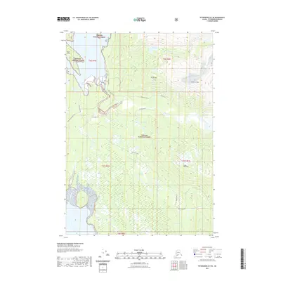
2021 Map of Petersburg D-3 NE
USGS Topo · Published 2021About this map
Tongass National Forest dominates this Alaskan landscape, where glacial meltwater and complex drainage systems define the geography of the Coast Mountains. The interior is accessible primarily by traditional routes like the Patterson River Trl and Muddy River Trl, which follow the natural contours of the river valleys. A network of significant waterways, including the North Blind River and Muddy River, meanders through the coastal lowlands toward the shoreline near Ruth Island. High-elevation landmarks such as Pirate Peak and Patterson Peaks overlook a series of remote water bodies like Ess Lake, Ruth Lake, and Brown Cove Lake. The mapping reflects a region where the natural environment remains the primary structure, with survey lines and township markers providing the only modern administrative overlay across the wilderness.
Find a feature on this map
23 named features on this map. Tap any name to fly to it.
Don’t see what you’re looking for? This feature index may not catch every label — zoom into the map to look around manually.
Map Details
Editions of this 2021 Petersburg D-3 NE Map
This is the sole edition of this map. No revisions or reprints were ever made.
Other maps of this area

1952 · Petersburg
USGS Topo · 1:250,000

1952 · Sumdum
USGS Topo · 1:250,000

1960 · Petersburg
USGS Topo · 1:250,000

1961 · Sumdum A-2
USGS Topo · 1:63,360

1961 · Petersburg D-3
USGS Topo · 1:63,360

1961 · Sumdum A-3
USGS Topo · 1:63,360

1961 · Petersburg D-2
USGS Topo · 1:63,360

1961 · Sumdum
USGS Topo · 1:250,000
1992 · Petersburg D-3 SW
USGS Topo · 1:25,000

1994 · Petersburg D-2
USGS Topo · 1:63,360