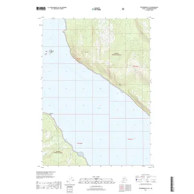
2017 Map of Petersburg D-3 SE
USGS Topo · Published 2017About this map
Tongass National Forest dominates this coastal landscape, where steep maritime slopes drop sharply into the waters of Frederick Sound. The terrain is defined by dramatic elevation changes, rising from the shoreline to the heights of Horn Mtn and the sheer faces of Horn Cliffs. Coastal features such as Ten Cove and Frederick Point provide reference points along the winding coastline, while the McDonald Islands sit just offshore. Inland, the presence of the Cabin Creek Reservoir indicates the management of freshwater resources within the forest boundaries. Numerous small drainages, including Crystal Cr and Moonshine Cr, carve through the dense timber of the Alexander Archipelago, illustrating the complex hydrology of this roadless wilderness area during the early twenty-first century.
Find a feature on this map
14 named features on this map. Tap any name to fly to it.
Don’t see what you’re looking for? This feature index may not catch every label — zoom into the map to look around manually.
Map Details
Editions of this 2017 Petersburg D-3 SE Map
This is the sole edition of this map. No revisions or reprints were ever made.
Other maps of this area

1948 · Petersburg C-2
USGS Topo · 1:63,360

1948 · Petersburg C-3
USGS Topo · 1:63,360

1951 · Petersburg C-2
USGS Topo · 1:63,360

1952 · Petersburg
USGS Topo · 1:250,000

1953 · Petersburg C-3
USGS Topo · 1:63,360

1960 · Petersburg
USGS Topo · 1:250,000

1961 · Petersburg D-3
USGS Topo · 1:63,360

1961 · Petersburg D-2
USGS Topo · 1:63,360
1992 · Petersburg D-3 SW
USGS Topo · 1:25,000
1992 · Petersburg C-3 NW
USGS Topo · 1:25,000