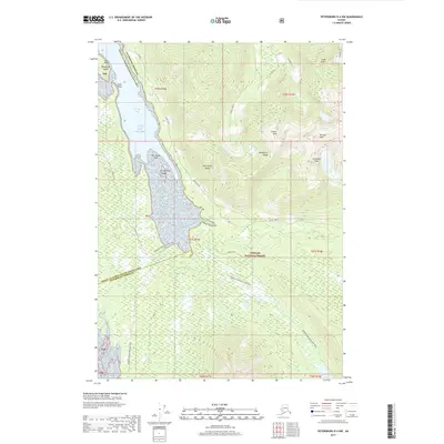
2017 Map of Petersburg D-4 NW
USGS Topo · Published 2017About this map
Kupreanof Island dominates this portion of the Tongass National Forest, where the waters of the Gulf of Alaska meet a complex network of coastal inlets and steep peaks. The geography is defined by the transition from Portage Bay into the interior wilds of the Missionary Range, with high points such as Chipp Peak and Putnam Peak towering over the drainages of Goose Creek. For those navigating the shoreline, landmarks like Flat Point, Hook Point, and Harrington Rock provide essential orientation in the marine environment of the Petersburg Borough. The interior remains largely untouched, characterized by the Portage Mountain Loop Trail winding through the forest toward Petersburg Lake, illustrating the isolation and specialized land use common in this part of Southeast Alaska.
Find a feature on this map
30 named features on this map. Tap any name to fly to it.
Don’t see what you’re looking for? This feature index may not catch every label — zoom into the map to look around manually.
Map Details
Editions of this 2017 Petersburg D-4 NW Map
This is the sole edition of this map. No revisions or reprints were ever made.
Other maps of this area

1948 · Sumdum A-4
USGS Topo · 1:63,360

1948 · Sumdum A-5
USGS Topo · 1:63,360

1948 · Petersburg D-5
USGS Topo · 1:63,360

1951 · Petersburg D-4
USGS Topo · 1:63,360

1951 · Sumdum A-4
USGS Topo · 1:63,360

1952 · Petersburg
USGS Topo · 1:250,000

1952 · Sumdum
USGS Topo · 1:250,000

1960 · Petersburg
USGS Topo · 1:250,000

1961 · Sumdum
USGS Topo · 1:250,000
1992 · Petersburg D-4 SE
USGS Topo · 1:25,000