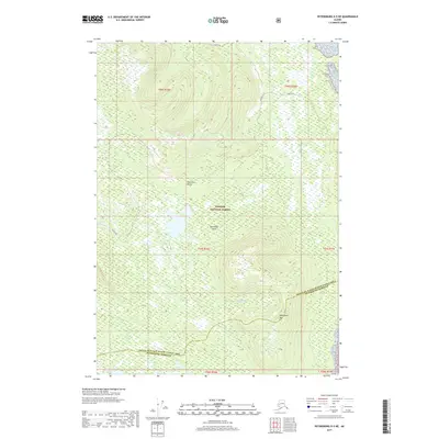
2017 Map of Petersburg D-5 NE
USGS Topo · Published 2017About this map
Kupreanof Island defines the heart of this coastal wilderness within the Tongass National Forest. The landscape is dominated by the high ridgelines of the Bohemian Range and the prominent peak of Kupreanof Mtn, which rises above a complex network of freshwater lakes and tidal inlets. Coastal features like Goose Cove and the nearby Bohemia S suggest the maritime accessibility of this region, while inland water bodies including Goose Lake and Towers Lake are connected by drainage systems such as Big Cr and Hamilton Cr. The map documents the boundary between the Prince of Wales-Hyder Census Area and Petersburg Borough, providing a clear look at the administrative and natural geography of this roadless Alaskan interior as it appeared in 2017.
Find a feature on this map
17 named features on this map. Tap any name to fly to it.
Don’t see what you’re looking for? This feature index may not catch every label — zoom into the map to look around manually.
Map Details
Editions of this 2017 Petersburg D-5 NE Map
This is the sole edition of this map. No revisions or reprints were ever made.
Other maps of this area

1948 · Sumdum A-4
USGS Topo · 1:63,360

1948 · Sumdum A-5
USGS Topo · 1:63,360

1948 · Petersburg D-5
USGS Topo · 1:63,360

1951 · Petersburg D-4
USGS Topo · 1:63,360

1951 · Sumdum A-4
USGS Topo · 1:63,360

1952 · Petersburg
USGS Topo · 1:250,000

1952 · Sumdum
USGS Topo · 1:250,000

1960 · Petersburg
USGS Topo · 1:250,000

1961 · Sumdum
USGS Topo · 1:250,000
1995 · Petersburg D-4
USGS Topo · 1:63,360