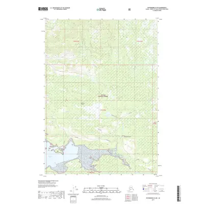
2017 Map of Petersburg D-6 NE
USGS Topo · Published 2017About this map
Kupreanof Island landscape, dominated by the timber and wilderness of the Tongass National Forest, reveals a complex network of coastal wetlands and interior drainages. Along the southern coastline, Hamilton Bay and the Keku Strait provide a marine interface for the island, where Seal Point and Little Hamilton Island mark the transition from open water to rugged shoreline. The map documents the vital terrestrial corridors of the area, including the Kake Road which skirts the coast, and interior pathways like the Goose Lake Trail and Hamilton Creek Trail. Notable freshwater features such as Goose Lake, the expansive Goose Marsh, and the Cathedral Falls on Cathedral Falls Cr illustrate the island's hydrological character. This survey is a precise record of the land-and-water economy of the Alexander Archipelago in the early 21st century.
Find a feature on this map
23 named features on this map. Tap any name to fly to it.
Don’t see what you’re looking for? This feature index may not catch every label — zoom into the map to look around manually.
Map Details
Editions of this 2017 Petersburg D-6 NE Map
This is the sole edition of this map. No revisions or reprints were ever made.
Other maps of this area

1948 · Sumdum A-5
USGS Topo · 1:63,360

1948 · Sumdum A-6
USGS Topo · 1:63,360

1948 · Petersburg D-6
USGS Topo · 1:63,360

1948 · Petersburg D-5
USGS Topo · 1:63,360

1951 · Petersburg D-6
USGS Topo · 1:63,360

1952 · Petersburg
USGS Topo · 1:250,000

1952 · Sumdum
USGS Topo · 1:250,000

1960 · Petersburg
USGS Topo · 1:250,000

1961 · Sumdum
USGS Topo · 1:250,000
1994 · Sumdum A-6
USGS Topo · 1:63,360