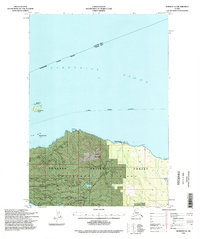
1994 Map of Sumdum A-6
USGS Topo · Published 1998About this map
Kupreanof Island defines the southern half of this coastal survey, where the dense timber of the Tongass National Forest meets the cold waters of the Alexander Archipelago. Mapping here reveals a landscape shaped by both natural features and industrial extraction, marked by numerous pits and topographic points like Turn Mountain and Slate 2. The northern waters of Frederick Sound serve as a primary maritime corridor, traced by the Alaska Marine Highway and guarded by the Lighthouse Reserve on Turnabout Island. To the southwest, the passage narrows into the Keku Strait, while Gunnuk Creek drains the interior elevations. This edition reflects the mid-1990s character of the Petersburg Ranger District, balancing maritime navigation with the resource extraction and forest management typical of the region's wilderness economy.
Find a feature on this map
16 named features on this map. Tap any name to fly to it.
Don’t see what you’re looking for? This feature index may not catch every label — zoom into the map to look around manually.
Map Details
Editions of this 1994 Sumdum A-6 Map
This is the sole edition of this map. No revisions or reprints were ever made.
Other maps of this area

1948 · Sitka B-1
USGS Topo · 1:63,360

1948 · Sumdum A-5
USGS Topo · 1:63,360

1948 · Sumdum A-6
USGS Topo · 1:63,360

1948 · Sumdum B-6
USGS Topo · 1:63,360

1948 · Sumdum B-5
USGS Topo · 1:63,360

1948 · Petersburg D-6
USGS Topo · 1:63,360

1948 · Port Alexander D-1
USGS Topo · 1:63,360

1948 · Sitka A-1
USGS Topo · 1:63,360

1948 · Petersburg D-5
USGS Topo · 1:63,360

1951 · Sitka
USGS Topo · 1:250,000