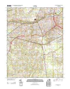
2013 Map of Petersburg
USGS Topo · Published 2013About this map
The Appomattox River carves through this central Virginia landscape, separating the established neighborhoods of Petersburg from the residential developments of Chesterfield County. Industrial and logistics footprints are evident at the Broadway Yards and the Petersburg City Landfill, while the city’s residential character is defined by a dense network of suburbs such as Ettrick, Blandford, and Pocahontas. Local history is anchored by The Crater, a site of significant American conflict, situated near the modern corridors of S Crater Rd.
Find a feature on this map
211 named features on this map. Tap any name to fly to it.
Don’t see what you’re looking for? This feature index may not catch every label — zoom into the map to look around manually.
Map Details
Editions of this 2013 Petersburg Map
This is the sole edition of this map. No revisions or reprints were ever made.
Other maps of this area

1894 · Bermuda Hundred
USGS Topo · 1:62,500

1894 · Petersburg
USGS Topo · 1:62,500

1897 · Amelia
USGS Topo · 1:125,000

1943 · Hopewell
USGS Topo · 1:31,680

1943 · Dinwiddie
USGS Topo · 1:24,000

1943 · Beach
USGS Topo · 1:24,000

1943 · Sutherland
USGS Topo · 1:24,000

1943 · Richmond
USGS Topo · 1:250,000
1944 · Beach
USGS Topo · 1:31,680

1944 · Reams
USGS Topo · 1:31,680