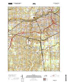
2019 Map of Petersburg
USGS Topo · Published 2019About this map
Petersburg National Battlefield dominates the landscape of this region, preserving the site of the Siege of Petersburg. The map meticulously documents the transition from the urban core of Petersburg and Colonial Heights to the surrounding agrarian and wooded areas of Dinwiddie County. Significant historical landmarks include The Crater and the extensive grounds of Blandford Cem, which, along with Peoples Memorial Cem and Rod of Sholom Cem, serve as important genealogical anchors for the community. The Appomattox River winds through the northern portion of the sheet, separating the neighborhoods of Ettrick and Matoaca from the main city. Further south, the landscape opens into areas like Poplar Grove National Cemetery and numerous swampy tributaries including Arthur Swamp and Warwick Swamp, illustrating the complex drainage patterns that shaped local development and military movement.
Find a feature on this map
56 named features on this map. Tap any name to fly to it.
Don’t see what you’re looking for? This feature index may not catch every label — zoom into the map to look around manually.
Map Details
Editions of this 2019 Petersburg Map
This is the sole edition of this map. No revisions or reprints were ever made.
Other maps of this area

1894 · Bermuda Hundred
USGS Topo · 1:62,500

1894 · Petersburg
USGS Topo · 1:62,500

1897 · Amelia
USGS Topo · 1:125,000

1943 · Hopewell
USGS Topo · 1:31,680

1943 · Dinwiddie
USGS Topo · 1:24,000

1943 · Beach
USGS Topo · 1:24,000

1943 · Sutherland
USGS Topo · 1:24,000

1943 · Richmond
USGS Topo · 1:250,000
1944 · Beach
USGS Topo · 1:31,680

1944 · Reams
USGS Topo · 1:31,680