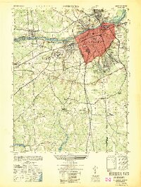
1949 Map of Petersburg
USGS Topo · Published 1949About this map
Petersburg dominates the confluence of the Appomattox River and its varied industrial and transportation infrastructure as it appeared just after the Second World War. The urban grid is defined by significant landmarks including the USC&GS Courthouse Tower 1941 and the campus of Virginia State College in nearby Ettrick. This map captures a landscape heavily shaped by its military history, prominently featuring the Petersburg National Military Park and the site of The Crater.
Find a feature on this map
46 named features on this map. Tap any name to fly to it.
Don’t see what you’re looking for? This feature index may not catch every label — zoom into the map to look around manually.
Map Details
Editions of this 1949 Petersburg Map
This is the sole edition of this map. No revisions or reprints were ever made.
Other maps of this area

1894 · Bermuda Hundred
USGS Topo · 1:62,500

1894 · Petersburg
USGS Topo · 1:62,500

1897 · Amelia
USGS Topo · 1:125,000

1943 · Hopewell
USGS Topo · 1:31,680

1943 · Dinwiddie
USGS Topo · 1:24,000

1943 · Beach
USGS Topo · 1:24,000

1943 · Sutherland
USGS Topo · 1:24,000

1943 · Richmond
USGS Topo · 1:250,000
1944 · Beach
USGS Topo · 1:31,680

1944 · Reams
USGS Topo · 1:31,680