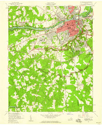
1952 Map of Petersburg
USGS Topo · Published 1959About this map
The Appomattox River carves through this mid-century landscape, separating the industrial and commercial core of Petersburg from Colonial Heights and Ettrick. This era marks the introduction of the Richmond-Petersburg Turnpike, a massive infrastructure project cutting through established neighborhoods and the grounds of Central State Hospital. The map reveals the intricate intersection of transportation and history, where the tracks of the Norfolk and Western and Atlantic Coast Line railroads converge near the city center.
Find a feature on this map
60 named features on this map. Tap any name to fly to it.
Don’t see what you’re looking for? This feature index may not catch every label — zoom into the map to look around manually.
Map Details
Editions of this 1952 Petersburg Map
This is the sole edition of this map. No revisions or reprints were ever made.
Other maps of this area

1894 · Bermuda Hundred
USGS Topo · 1:62,500

1894 · Petersburg
USGS Topo · 1:62,500

1897 · Amelia
USGS Topo · 1:125,000

1943 · Hopewell
USGS Topo · 1:31,680

1943 · Dinwiddie
USGS Topo · 1:24,000

1943 · Beach
USGS Topo · 1:24,000

1943 · Sutherland
USGS Topo · 1:24,000

1943 · Richmond
USGS Topo · 1:250,000
1944 · Beach
USGS Topo · 1:31,680

1944 · Reams
USGS Topo · 1:31,680