
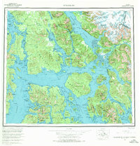
1960 Map of Petersburg
USGS Topo · Published 1980About this map
Petersburg and Wrangell anchor this coastal survey of Southeast Alaska, revealing the intricate geography of the Alexander Archipelago. The map tracks the complex waterways of the Tongass National Forest, from the broad Sumner Strait to the narrow, tidal Rocky Pass. Settlements like Kake on Kupreanof Island and the cannery site at Hamilton are connected by a network of sounds and canals rather than roads. The interior is defined by steep peaks such as Kupreanof Mountain and Garnet Mtn, while the eastern edge marks the international boundary between the United States and Canada along the Stikine River corridor. This compilation provides a look at the region’s maritime-dependent economy and settlement patterns before modern infrastructure reached these isolated islands.
Find a feature on this map
61 named features on this map. Tap any name to fly to it.
Don’t see what you’re looking for? This feature index may not catch every label — zoom into the map to look around manually.
Map Details
Editions of this 1960 Petersburg Map
3 editions found

Historical Maps of Petersburg Through Time
659 maps found

1948 Craig A-1
Prince of Wales-Hyder Borough, AK

1948 Craig A-2
Prince of Wales-Hyder Borough, AK

1948 Craig A-3
Prince of Wales-Hyder Borough, AK

1948 Craig A-4
Prince of Wales-Hyder Borough, AK

1948 Craig A-5
Prince of Wales-Hyder Borough, AK

1948 Craig B-5
Prince of Wales-Hyder Borough, AK

1948 Craig B-6
Prince of Wales-Hyder Borough, AK

1948 Dixon Entrance C-1
Prince of Wales-Hyder Borough, AK

1948 Dixon Entrance C-3
Prince of Wales-Hyder Borough, AK

1948 Dixon Entrance D-1
Prince of Wales-Hyder Borough, AK

1948 Dixon Entrance D-2
Prince of Wales-Hyder Borough, AK

1948 Dixon Entrance D-3
Prince of Wales-Hyder Borough, AK

1948 Dixon Entrance D-4
Prince of Wales-Hyder Borough, AK

1948 Dixon Entrance D-5
Prince of Wales-Hyder Borough, AK

1948 Ketchikan A-6
Prince of Wales-Hyder Borough, AK

1948 Petersburg A-2
Prince of Wales-Hyder Borough, AK

1948 Petersburg A-6
Prince of Wales-Hyder Borough, AK

1948 Petersburg B-3
Prince of Wales-Hyder Borough, AK

1948 Petersburg B-6
Prince of Wales-Hyder Borough, AK

1948 Prince Rupert D-6
Prince of Wales-Hyder Borough, AK

1949 Craig B-1
Prince of Wales-Hyder Borough, AK

1949 Craig B-2
Prince of Wales-Hyder Borough, AK

1949 Craig B-3
Prince of Wales-Hyder Borough, AK

1949 Craig B-4
Prince of Wales-Hyder Borough, AK

1949 Craig C-2
Prince of Wales-Hyder Borough, AK

1949 Craig C-3
Prince of Wales-Hyder Borough, AK

1949 Craig C-4
Prince of Wales-Hyder Borough, AK

1949 Craig D-1
Prince of Wales-Hyder Borough, AK

1949 Craig D-2
Prince of Wales-Hyder Borough, AK

1949 Craig D-3
Prince of Wales-Hyder Borough, AK

1949 Craig D-4
Prince of Wales-Hyder Borough, AK

1949 Ketchikan C-6
Prince of Wales-Hyder Borough, AK

1949 Petersburg A-3
Prince of Wales-Hyder Borough, AK

1949 Petersburg A-4
Prince of Wales-Hyder Borough, AK

1949 Petersburg A-5
Prince of Wales-Hyder Borough, AK

1949 Petersburg B-4
Prince of Wales-Hyder Borough, AK

1949 Petersburg B-5
Prince of Wales-Hyder Borough, AK

1950 Craig B-1
Prince of Wales-Hyder Borough, AK

1950 Craig C-1
Prince of Wales-Hyder Borough, AK

1950 Craig D-3
Prince of Wales-Hyder Borough, AK

1951 Bradfield Canal
Prince of Wales-Hyder Borough, AK

1951 Craig A-2
Prince of Wales-Hyder Borough, AK

1951 Craig A-3
Prince of Wales-Hyder Borough, AK

1951 Craig A-4
Prince of Wales-Hyder Borough, AK

1951 Craig B-2
Prince of Wales-Hyder Borough, AK

1951 Craig B-3
Prince of Wales-Hyder Borough, AK

1951 Craig B-4
Prince of Wales-Hyder Borough, AK

1951 Craig C-1
Prince of Wales-Hyder Borough, AK

1951 Craig C-2
Prince of Wales-Hyder Borough, AK

1951 Craig C-3
Prince of Wales-Hyder Borough, AK

1951 Craig C-4
Prince of Wales-Hyder Borough, AK

1951 Craig C-5
Prince of Wales-Hyder Borough, AK

1951 Craig C-6
Prince of Wales-Hyder Borough, AK

1951 Craig D-1
Prince of Wales-Hyder Borough, AK

1951 Craig D-2
Prince of Wales-Hyder Borough, AK

1951 Craig D-4
Prince of Wales-Hyder Borough, AK

1951 Craig D-5
Prince of Wales-Hyder Borough, AK

1951 Craig D-6
Prince of Wales-Hyder Borough, AK

1951 Dixon Entrance D-2
Prince of Wales-Hyder Borough, AK

1951 Dixon Entrance D-3
Prince of Wales-Hyder Borough, AK

1951 Dixon Entrance D-4
Prince of Wales-Hyder Borough, AK

1951 Dixon Entrance
Prince of Wales-Hyder Borough, AK

1951 Petersburg A-6
Prince of Wales-Hyder Borough, AK

1951 Petersburg B-3
Prince of Wales-Hyder Borough, AK

1951 Petersburg B-4
Prince of Wales-Hyder Borough, AK

1951 Petersburg B-6
Prince of Wales-Hyder Borough, AK

1951 Prince Rupert D-6
Prince of Wales-Hyder Borough, AK

1951 Prince Rupert
Prince of Wales-Hyder Borough, AK

1952 Ketchikan C-6
Prince of Wales-Hyder Borough, AK

1952 Ketchikan D-6
Prince of Wales-Hyder Borough, AK

1952 Petersburg
Prince of Wales-Hyder Borough, AK

1953 Ketchikan D-6
Prince of Wales-Hyder Borough, AK

1953 Petersburg A-2
Prince of Wales-Hyder Borough, AK

1953 Petersburg A-3
Prince of Wales-Hyder Borough, AK

1953 Petersburg A-4
Prince of Wales-Hyder Borough, AK

1953 Petersburg A-5
Prince of Wales-Hyder Borough, AK

1953 Petersburg B-5
Prince of Wales-Hyder Borough, AK

1954 Bradfield Canal
Prince of Wales-Hyder Borough, AK

1955 Bradfield Canal A-1
Prince of Wales-Hyder Borough, AK

1955 Bradfield canal A-2
Prince of Wales-Hyder Borough, AK

1955 Bradfield canal A-3
Prince of Wales-Hyder Borough, AK

1955 Bradfield canal A-4
Prince of Wales-Hyder Borough, AK

1955 Bradfield Canal A-5
Prince of Wales-Hyder Borough, AK

1955 Bradfield canal A-6
Prince of Wales-Hyder Borough, AK

1955 Bradfield canal B-2
Prince of Wales-Hyder Borough, AK

1955 Bradfield canal B-3
Prince of Wales-Hyder Borough, AK

1955 Bradfield canal B-4
Prince of Wales-Hyder Borough, AK

1955 Bradfield Canal
Prince of Wales-Hyder Borough, AK

1955 Ketchikan A-1
Prince of Wales-Hyder Borough, AK

1955 Ketchikan A-2
Prince of Wales-Hyder Borough, AK

1955 Ketchikan A-3
Prince of Wales-Hyder Borough, AK

1955 Ketchikan A-4
Prince of Wales-Hyder Borough, AK

1955 Ketchikan A-5
Prince of Wales-Hyder Borough, AK

1955 Ketchikan B-1
Prince of Wales-Hyder Borough, AK

1955 Ketchikan B-2
Prince of Wales-Hyder Borough, AK

1955 Ketchikan B-3
Prince of Wales-Hyder Borough, AK

1955 Ketchikan C-1
Prince of Wales-Hyder Borough, AK

1955 Ketchikan C-2
Prince of Wales-Hyder Borough, AK

1955 Ketchikan C-3
Prince of Wales-Hyder Borough, AK

1955 Ketchikan D-1
Prince of Wales-Hyder Borough, AK

1955 Ketchikan D-2
Prince of Wales-Hyder Borough, AK

1955 Ketchikan D-3
Prince of Wales-Hyder Borough, AK

1955 Prince Rupert D-1
Prince of Wales-Hyder Borough, AK

1955 Prince Rupert D-2
Prince of Wales-Hyder Borough, AK

1955 Prince Rupert D-3
Prince of Wales-Hyder Borough, AK

1955 Prince Rupert D-4
Prince of Wales-Hyder Borough, AK

1955 Prince Rupert D-5
Prince of Wales-Hyder Borough, AK

1958 Prince Rupert C-2 and C-3
Prince of Wales-Hyder Borough, AK

1959 Dixon Entrance
Prince of Wales-Hyder Borough, AK

1959 Prince Rupert
Prince of Wales-Hyder Borough, AK
1960 Petersburg
Prince of Wales-Hyder Borough, AK

1964 Prince Rupert
Prince of Wales-Hyder Borough, AK

1973 Bradfield Canal B-2
Prince of Wales-Hyder Borough, AK

1994 Craig A-4
Prince of Wales-Hyder Borough, AK

1994 Craig C-2
Prince of Wales-Hyder Borough, AK

1994 Craig C-3
Prince of Wales-Hyder Borough, AK

1994 Craig D-2
Prince of Wales-Hyder Borough, AK

1994 Craig D-3
Prince of Wales-Hyder Borough, AK

1994 Craig D-4
Prince of Wales-Hyder Borough, AK

1994 Dixon Entrance C-3
Prince of Wales-Hyder Borough, AK

1994 Dixon Entrance D-1
Prince of Wales-Hyder Borough, AK

1994 Petersburg A-3
Prince of Wales-Hyder Borough, AK

1994 Petersburg A-4
Prince of Wales-Hyder Borough, AK

1995 Bradfield Canal A-4
Prince of Wales-Hyder Borough, AK

1995 Ketchikan C-6
Prince of Wales-Hyder Borough, AK

1995 Petersburg A-2
Prince of Wales-Hyder Borough, AK

1995 Petersburg A-5
Prince of Wales-Hyder Borough, AK

1995 Petersburg B-3
Prince of Wales-Hyder Borough, AK

1995 Petersburg B-4
Prince of Wales-Hyder Borough, AK

1995 Petersburg B-5
Prince of Wales-Hyder Borough, AK

1996 Bradfield Canal A-1
Prince of Wales-Hyder Borough, AK

1996 Craig A-2
Prince of Wales-Hyder Borough, AK

1996 Craig D-5
Prince of Wales-Hyder Borough, AK

1996 Ketchikan C-2
Prince of Wales-Hyder Borough, AK

1996 Ketchikan C-3
Prince of Wales-Hyder Borough, AK

1996 Ketchikan D-2
Prince of Wales-Hyder Borough, AK

1996 Ketchikan D-3
Prince of Wales-Hyder Borough, AK

1997 Bradfield Canal A-1
Prince of Wales-Hyder Borough, AK

1997 Craig A-1
Prince of Wales-Hyder Borough, AK

1997 Craig A-3
Prince of Wales-Hyder Borough, AK

1997 Craig B-2
Prince of Wales-Hyder Borough, AK

2000 Bradfield Canal A-1
Prince of Wales-Hyder Borough, AK

2000 Bradfield Canal A-2
Prince of Wales-Hyder Borough, AK

2000 Bradfield Canal A-6
Prince of Wales-Hyder Borough, AK

2000 Craig B-5
Prince of Wales-Hyder Borough, AK

2000 Craig B-6
Prince of Wales-Hyder Borough, AK

2000 Craig D-1
Prince of Wales-Hyder Borough, AK

2000 Ketchikan D-6
Prince of Wales-Hyder Borough, AK

2017 Bradfield Canal A-4 NE
Prince of Wales-Hyder Borough, AK

2017 Bradfield Canal A-4 NW
Prince of Wales-Hyder Borough, AK

2017 Bradfield Canal A-4 SE
Prince of Wales-Hyder Borough, AK

2017 Bradfield Canal A-4 SW
Prince of Wales-Hyder Borough, AK

2017 Bradfield Canal A-5 NE
Prince of Wales-Hyder Borough, AK

2017 Bradfield Canal A-5 SE
Prince of Wales-Hyder Borough, AK

2017 Bradfield Canal A-5 SW
Prince of Wales-Hyder Borough, AK

2017 Bradfield Canal A-6 SE
Prince of Wales-Hyder Borough, AK

2017 Bradfield Canal A-6 SW
Prince of Wales-Hyder Borough, AK

2017 Bradfield Canal B-4 NE
Prince of Wales-Hyder Borough, AK

2017 Bradfield Canal B-4 SE
Prince of Wales-Hyder Borough, AK

2017 Craig A-1 NE
Prince of Wales-Hyder Borough, AK

2017 Craig A-1 NW
Prince of Wales-Hyder Borough, AK

2017 Craig A-1 SE
Prince of Wales-Hyder Borough, AK

2017 Craig A-1 SW
Prince of Wales-Hyder Borough, AK

2017 Craig A-2 NE
Prince of Wales-Hyder Borough, AK

2017 Craig A-2 NW
Prince of Wales-Hyder Borough, AK

2017 Craig A-2 SE
Prince of Wales-Hyder Borough, AK

2017 Craig A-2 SW
Prince of Wales-Hyder Borough, AK

2017 Craig A-3 NE
Prince of Wales-Hyder Borough, AK

2017 Craig A-3 NW
Prince of Wales-Hyder Borough, AK

2017 Craig A-3 SE
Prince of Wales-Hyder Borough, AK

2017 Craig A-3 SW
Prince of Wales-Hyder Borough, AK

2017 Craig A-4 NE
Prince of Wales-Hyder Borough, AK

2017 Craig A-4 NW
Prince of Wales-Hyder Borough, AK

2017 Craig A-4 SE
Prince of Wales-Hyder Borough, AK

2017 Craig A-4 SW
Prince of Wales-Hyder Borough, AK

2017 Craig A-5 NE
Prince of Wales-Hyder Borough, AK

2017 Craig A-5 NW
Prince of Wales-Hyder Borough, AK

2017 Craig B-1 NE
Prince of Wales-Hyder Borough, AK

2017 Craig B-1 NW
Prince of Wales-Hyder Borough, AK

2017 Craig B-1 SE
Prince of Wales-Hyder Borough, AK

2017 Craig B-1 SW
Prince of Wales-Hyder Borough, AK

2017 Craig B-2 NE
Prince of Wales-Hyder Borough, AK

2017 Craig B-2 NW
Prince of Wales-Hyder Borough, AK

2017 Craig B-2 SE
Prince of Wales-Hyder Borough, AK

2017 Craig B-2 SW
Prince of Wales-Hyder Borough, AK

2017 Craig B-3 NE
Prince of Wales-Hyder Borough, AK

2017 Craig B-3 NW
Prince of Wales-Hyder Borough, AK

2017 Craig B-3 SE
Prince of Wales-Hyder Borough, AK

2017 Craig B-3 SW
Prince of Wales-Hyder Borough, AK

2017 Craig B-4 NE
Prince of Wales-Hyder Borough, AK

2017 Craig B-4 NW
Prince of Wales-Hyder Borough, AK

2017 Craig B-4 SE
Prince of Wales-Hyder Borough, AK

2017 Craig B-4 SW
Prince of Wales-Hyder Borough, AK

2017 Craig B-5 NE
Prince of Wales-Hyder Borough, AK

2017 Craig B-5 NW
Prince of Wales-Hyder Borough, AK

2017 Craig B-5 SE
Prince of Wales-Hyder Borough, AK

2017 Craig B-5 SW
Prince of Wales-Hyder Borough, AK

2017 Craig B-6 NE
Prince of Wales-Hyder Borough, AK

2017 Craig B-6 SE
Prince of Wales-Hyder Borough, AK

2017 Craig C-1 NE
Prince of Wales-Hyder Borough, AK

2017 Craig C-1 NW
Prince of Wales-Hyder Borough, AK

2017 Craig C-1 SE
Prince of Wales-Hyder Borough, AK

2017 Craig C-1 SW
Prince of Wales-Hyder Borough, AK

2017 Craig C-2 NE
Prince of Wales-Hyder Borough, AK

2017 Craig C-2 NW
Prince of Wales-Hyder Borough, AK

2017 Craig C-2 SE
Prince of Wales-Hyder Borough, AK

2017 Craig C-2 SW
Prince of Wales-Hyder Borough, AK

2017 Craig C-3 NE
Prince of Wales-Hyder Borough, AK

2017 Craig C-3 NW
Prince of Wales-Hyder Borough, AK

2017 Craig C-3 SE
Prince of Wales-Hyder Borough, AK

2017 Craig C-3 SW
Prince of Wales-Hyder Borough, AK

2017 Craig C-4 NE
Prince of Wales-Hyder Borough, AK

2017 Craig C-4 NW
Prince of Wales-Hyder Borough, AK

2017 Craig C-4 SE
Prince of Wales-Hyder Borough, AK

2017 Craig C-4 SW
Prince of Wales-Hyder Borough, AK

2017 Craig C-5 NE
Prince of Wales-Hyder Borough, AK

2017 Craig C-5 NW
Prince of Wales-Hyder Borough, AK

2017 Craig C-5 SE
Prince of Wales-Hyder Borough, AK

2017 Craig C-5 SW
Prince of Wales-Hyder Borough, AK

2017 Craig C-6 SE
Prince of Wales-Hyder Borough, AK

2017 Craig D-1 NE
Prince of Wales-Hyder Borough, AK

2017 Craig D-1 NW
Prince of Wales-Hyder Borough, AK

2017 Craig D-1 SE
Prince of Wales-Hyder Borough, AK

2017 Craig D-1 SW
Prince of Wales-Hyder Borough, AK

2017 Craig D-2 NE
Prince of Wales-Hyder Borough, AK

2017 Craig D-2 NW
Prince of Wales-Hyder Borough, AK

2017 Craig D-2 SE
Prince of Wales-Hyder Borough, AK

2017 Craig D-2 SW
Prince of Wales-Hyder Borough, AK

2017 Craig D-3 NE
Prince of Wales-Hyder Borough, AK

2017 Craig D-3 NW
Prince of Wales-Hyder Borough, AK

2017 Craig D-3 SE
Prince of Wales-Hyder Borough, AK

2017 Craig D-3 SW
Prince of Wales-Hyder Borough, AK

2017 Craig D-4 NE
Prince of Wales-Hyder Borough, AK

2017 Craig D-4 NW
Prince of Wales-Hyder Borough, AK

2017 Craig D-4 SE
Prince of Wales-Hyder Borough, AK

2017 Craig D-4 SW
Prince of Wales-Hyder Borough, AK

2017 Craig D-5 NE
Prince of Wales-Hyder Borough, AK

2017 Craig D-5 NW
Prince of Wales-Hyder Borough, AK

2017 Craig D-5 SE
Prince of Wales-Hyder Borough, AK

2017 Craig D-5 SW
Prince of Wales-Hyder Borough, AK

2017 Craig D-6 NE
Prince of Wales-Hyder Borough, AK

2017 Craig D-6 NW
Prince of Wales-Hyder Borough, AK

2017 Craig D-6 SE
Prince of Wales-Hyder Borough, AK

2017 Craig D-6 SW
Prince of Wales-Hyder Borough, AK

2017 Dixon Entrance C-1 NE
Prince of Wales-Hyder Borough, AK

2017 Dixon Entrance C-1 NW
Prince of Wales-Hyder Borough, AK

2017 Dixon Entrance C-3 NE
Prince of Wales-Hyder Borough, AK

2017 Dixon Entrance C-3 NW
Prince of Wales-Hyder Borough, AK

2017 Dixon Entrance D-1 NE
Prince of Wales-Hyder Borough, AK

2017 Dixon Entrance D-1 NW
Prince of Wales-Hyder Borough, AK

2017 Dixon Entrance D-1 SE
Prince of Wales-Hyder Borough, AK

2017 Dixon Entrance D-1 SW
Prince of Wales-Hyder Borough, AK

2017 Dixon Entrance D-2 NE
Prince of Wales-Hyder Borough, AK

2017 Dixon Entrance D-2 NW
Prince of Wales-Hyder Borough, AK

2017 Dixon Entrance D-2 SE
Prince of Wales-Hyder Borough, AK

2017 Dixon Entrance D-2 SW
Prince of Wales-Hyder Borough, AK

2017 Dixon Entrance D-3 NE
Prince of Wales-Hyder Borough, AK

2017 Dixon Entrance D-3 NW
Prince of Wales-Hyder Borough, AK

2017 Dixon Entrance D-3 SE
Prince of Wales-Hyder Borough, AK

2017 Dixon Entrance D-3 SW
Prince of Wales-Hyder Borough, AK

2017 Ketchikan A-4 NE
Prince of Wales-Hyder Borough, AK

2017 Ketchikan A-4 NW
Prince of Wales-Hyder Borough, AK

2017 Ketchikan A-4 SE
Prince of Wales-Hyder Borough, AK

2017 Ketchikan A-4 SW
Prince of Wales-Hyder Borough, AK

2017 Ketchikan A-5 NE
Prince of Wales-Hyder Borough, AK

2017 Ketchikan A-5 NW
Prince of Wales-Hyder Borough, AK

2017 Ketchikan A-5 SE
Prince of Wales-Hyder Borough, AK

2017 Ketchikan A-5 SW
Prince of Wales-Hyder Borough, AK

2017 Ketchikan A-6 NW
Prince of Wales-Hyder Borough, AK

2017 Ketchikan A-6 SW
Prince of Wales-Hyder Borough, AK

2017 Ketchikan C-6 NW
Prince of Wales-Hyder Borough, AK

2017 Ketchikan D-4 NE
Prince of Wales-Hyder Borough, AK

2017 Ketchikan D-5 NW
Prince of Wales-Hyder Borough, AK

2017 Ketchikan D-6 NE
Prince of Wales-Hyder Borough, AK

2017 Ketchikan D-6 NW
Prince of Wales-Hyder Borough, AK

2017 Ketchikan D-6 SE
Prince of Wales-Hyder Borough, AK

2017 Ketchikan D-6 SW
Prince of Wales-Hyder Borough, AK

2017 Petersburg A-2 SW
Prince of Wales-Hyder Borough, AK

2017 Petersburg A-3 NE
Prince of Wales-Hyder Borough, AK

2017 Petersburg A-3 NW
Prince of Wales-Hyder Borough, AK

2017 Petersburg A-3 SE
Prince of Wales-Hyder Borough, AK

2017 Petersburg A-3 SW
Prince of Wales-Hyder Borough, AK

2017 Petersburg A-4 NE
Prince of Wales-Hyder Borough, AK

2017 Petersburg A-4 NW
Prince of Wales-Hyder Borough, AK

2017 Petersburg A-4 SE
Prince of Wales-Hyder Borough, AK

2017 Petersburg A-4 SW
Prince of Wales-Hyder Borough, AK

2017 Petersburg A-5 NE
Prince of Wales-Hyder Borough, AK

2017 Petersburg A-5 NW
Prince of Wales-Hyder Borough, AK

2017 Petersburg A-5 SE
Prince of Wales-Hyder Borough, AK

2017 Petersburg A-5 SW
Prince of Wales-Hyder Borough, AK

2017 Petersburg A-6 SE
Prince of Wales-Hyder Borough, AK

2017 Petersburg A-6 SW
Prince of Wales-Hyder Borough, AK

2017 Petersburg B-3 SW
Prince of Wales-Hyder Borough, AK

2017 Petersburg B-4 NW
Prince of Wales-Hyder Borough, AK

2017 Petersburg B-4 SE
Prince of Wales-Hyder Borough, AK

2017 Petersburg B-4 SW
Prince of Wales-Hyder Borough, AK

2017 Petersburg B-5 NE
Prince of Wales-Hyder Borough, AK

2017 Petersburg B-5 NW
Prince of Wales-Hyder Borough, AK

2017 Petersburg B-5 SE
Prince of Wales-Hyder Borough, AK

2017 Petersburg B-5 SW
Prince of Wales-Hyder Borough, AK

2017 Petersburg B-6 SE
Prince of Wales-Hyder Borough, AK

2018 Bradfield Canal A-1 SE
Prince of Wales-Hyder Borough, AK

2018 Bradfield Canal A-1 SW
Prince of Wales-Hyder Borough, AK

2018 Bradfield Canal A-2 NE
Prince of Wales-Hyder Borough, AK

2018 Bradfield Canal A-2 NW
Prince of Wales-Hyder Borough, AK

2018 Bradfield Canal A-2 SE
Prince of Wales-Hyder Borough, AK

2018 Bradfield Canal A-2 SW
Prince of Wales-Hyder Borough, AK

2018 Bradfield Canal A-3 NE
Prince of Wales-Hyder Borough, AK

2018 Bradfield Canal A-3 NW
Prince of Wales-Hyder Borough, AK

2018 Bradfield Canal A-3 SE
Prince of Wales-Hyder Borough, AK

2018 Bradfield Canal A-3 SW
Prince of Wales-Hyder Borough, AK

2018 Bradfield Canal B-2 SW
Prince of Wales-Hyder Borough, AK

2018 Bradfield Canal B-3 NW
Prince of Wales-Hyder Borough, AK

2018 Bradfield Canal B-3 SE
Prince of Wales-Hyder Borough, AK

2018 Bradfield Canal B-3 SW
Prince of Wales-Hyder Borough, AK

2018 Craig C-6 NE
Prince of Wales-Hyder Borough, AK

2018 Craig D-7 NE
Prince of Wales-Hyder Borough, AK

2018 Craig D-7 NW
Prince of Wales-Hyder Borough, AK

2018 Craig D-7 SE
Prince of Wales-Hyder Borough, AK

2018 Craig D-7 SW
Prince of Wales-Hyder Borough, AK

2018 Craig D-8 NE
Prince of Wales-Hyder Borough, AK

2018 Craig D-8 NW
Prince of Wales-Hyder Borough, AK

2018 Craig D-8 SE
Prince of Wales-Hyder Borough, AK

2018 Dixon Entrance C-1 OE E NW
Prince of Wales-Hyder Borough, AK

2018 Dixon Entrance C-3 OE E NE
Prince of Wales-Hyder Borough, AK

2018 Dixon Entrance C-3 OE E NW
Prince of Wales-Hyder Borough, AK

2018 Dixon Entrance D-4 NE
Prince of Wales-Hyder Borough, AK

2018 Dixon Entrance D-4 NW
Prince of Wales-Hyder Borough, AK

2018 Dixon Entrance D-4 SE
Prince of Wales-Hyder Borough, AK

2018 Dixon Entrance D-5 NW
Prince of Wales-Hyder Borough, AK

2018 Dixon Entrance D-5 OE S NW
Prince of Wales-Hyder Borough, AK

2018 Dixon Entrance D-5 SW
Prince of Wales-Hyder Borough, AK

2018 Dixon Entrance D-6 NE
Prince of Wales-Hyder Borough, AK

2018 Dixon Entrance D-6 SE
Prince of Wales-Hyder Borough, AK

2018 Ketchikan A-1 NE
Prince of Wales-Hyder Borough, AK

2018 Ketchikan A-1 NW
Prince of Wales-Hyder Borough, AK

2018 Ketchikan A-1 SE
Prince of Wales-Hyder Borough, AK

2018 Ketchikan A-1 SW
Prince of Wales-Hyder Borough, AK

2018 Ketchikan A-2 NE
Prince of Wales-Hyder Borough, AK

2018 Ketchikan A-2 NW
Prince of Wales-Hyder Borough, AK

2018 Ketchikan A-2 SE
Prince of Wales-Hyder Borough, AK

2018 Ketchikan A-2 SW
Prince of Wales-Hyder Borough, AK

2018 Ketchikan A-3 NE
Prince of Wales-Hyder Borough, AK

2018 Ketchikan A-3 NW
Prince of Wales-Hyder Borough, AK

2018 Ketchikan A-3 SE
Prince of Wales-Hyder Borough, AK

2018 Ketchikan A-3 SW
Prince of Wales-Hyder Borough, AK

2018 Ketchikan B-1 NE
Prince of Wales-Hyder Borough, AK

2018 Ketchikan B-1 NW
Prince of Wales-Hyder Borough, AK

2018 Ketchikan B-1 OE E SW
Prince of Wales-Hyder Borough, AK

2018 Ketchikan B-1 SE
Prince of Wales-Hyder Borough, AK

2018 Ketchikan B-1 SW
Prince of Wales-Hyder Borough, AK

2018 Ketchikan B-2 NE
Prince of Wales-Hyder Borough, AK

2018 Ketchikan B-2 NW
Prince of Wales-Hyder Borough, AK

2018 Ketchikan B-2 SE
Prince of Wales-Hyder Borough, AK

2018 Ketchikan B-2 SW
Prince of Wales-Hyder Borough, AK

2018 Ketchikan B-3 NE
Prince of Wales-Hyder Borough, AK

2018 Ketchikan B-3 NW
Prince of Wales-Hyder Borough, AK

2018 Ketchikan B-3 SE
Prince of Wales-Hyder Borough, AK

2018 Ketchikan B-3 SW
Prince of Wales-Hyder Borough, AK

2018 Ketchikan C-1 NE
Prince of Wales-Hyder Borough, AK

2018 Ketchikan C-1 NW
Prince of Wales-Hyder Borough, AK

2018 Ketchikan C-1 SE
Prince of Wales-Hyder Borough, AK

2018 Ketchikan C-1 SW
Prince of Wales-Hyder Borough, AK

2018 Ketchikan C-2 NE
Prince of Wales-Hyder Borough, AK

2018 Ketchikan C-2 NW
Prince of Wales-Hyder Borough, AK

2018 Ketchikan C-2 SE
Prince of Wales-Hyder Borough, AK

2018 Ketchikan C-2 SW
Prince of Wales-Hyder Borough, AK

2018 Ketchikan C-3 NE
Prince of Wales-Hyder Borough, AK

2018 Ketchikan C-3 NW
Prince of Wales-Hyder Borough, AK

2018 Ketchikan C-3 SE
Prince of Wales-Hyder Borough, AK

2018 Ketchikan C-3 SW
Prince of Wales-Hyder Borough, AK

2018 Ketchikan D-1 NE
Prince of Wales-Hyder Borough, AK

2018 Ketchikan D-1 NW
Prince of Wales-Hyder Borough, AK

2018 Ketchikan D-1 SE
Prince of Wales-Hyder Borough, AK

2018 Ketchikan D-1 SW
Prince of Wales-Hyder Borough, AK

2018 Ketchikan D-2 NE
Prince of Wales-Hyder Borough, AK

2018 Ketchikan D-2 NW
Prince of Wales-Hyder Borough, AK

2018 Ketchikan D-2 SE
Prince of Wales-Hyder Borough, AK

2018 Ketchikan D-2 SW
Prince of Wales-Hyder Borough, AK

2018 Ketchikan D-3 NE
Prince of Wales-Hyder Borough, AK

2018 Ketchikan D-3 NW
Prince of Wales-Hyder Borough, AK

2018 Ketchikan D-3 SE
Prince of Wales-Hyder Borough, AK

2018 Ketchikan D-3 SW
Prince of Wales-Hyder Borough, AK

2018 Prince Rupert C-2 NW
Prince of Wales-Hyder Borough, AK

2018 Prince Rupert C-3 NE
Prince of Wales-Hyder Borough, AK

2018 Prince Rupert D-1 NW
Prince of Wales-Hyder Borough, AK

2018 Prince Rupert D-2 NE
Prince of Wales-Hyder Borough, AK

2018 Prince Rupert D-2 NW
Prince of Wales-Hyder Borough, AK

2018 Prince Rupert D-2 SE
Prince of Wales-Hyder Borough, AK

2018 Prince Rupert D-2 SW
Prince of Wales-Hyder Borough, AK

2018 Prince Rupert D-3 NE
Prince of Wales-Hyder Borough, AK

2018 Prince Rupert D-3 NW
Prince of Wales-Hyder Borough, AK

2018 Prince Rupert D-3 SE
Prince of Wales-Hyder Borough, AK

2018 Prince Rupert D-3 SW
Prince of Wales-Hyder Borough, AK

2018 Prince Rupert D-4 NW
Prince of Wales-Hyder Borough, AK

2018 Prince Rupert D-4 SW
Prince of Wales-Hyder Borough, AK

2018 Prince Rupert D-5 NE
Prince of Wales-Hyder Borough, AK

2018 Prince Rupert D-5 NW
Prince of Wales-Hyder Borough, AK

2018 Prince Rupert D-5 SE
Prince of Wales-Hyder Borough, AK

2018 Prince Rupert D-5 SW
Prince of Wales-Hyder Borough, AK

2018 Prince Rupert D-6 NW
Prince of Wales-Hyder Borough, AK

2018 Prince Rupert D-6 SE
Prince of Wales-Hyder Borough, AK

2018 Prince Rupert D-6 SW
Prince of Wales-Hyder Borough, AK

2020 Craig A-5 SE
Prince of Wales-Hyder Borough, AK

2020 Petersburg A-6 NE
Prince of Wales-Hyder Borough, AK

2020 Prince Rupert D-4 NE
Prince of Wales-Hyder Borough, AK

2021 Bradfield Canal A-1 SE
Prince of Wales-Hyder Borough, AK

2021 Bradfield Canal A-1 SW
Prince of Wales-Hyder Borough, AK

2021 Bradfield Canal A-2 NE
Prince of Wales-Hyder Borough, AK

2021 Bradfield Canal A-2 NW
Prince of Wales-Hyder Borough, AK

2021 Bradfield Canal A-2 SE
Prince of Wales-Hyder Borough, AK

2021 Bradfield Canal A-2 SW
Prince of Wales-Hyder Borough, AK

2021 Bradfield Canal A-3 NE
Prince of Wales-Hyder Borough, AK

2021 Bradfield Canal A-3 NW
Prince of Wales-Hyder Borough, AK

2021 Bradfield Canal A-3 SE
Prince of Wales-Hyder Borough, AK

2021 Bradfield Canal A-3 SW
Prince of Wales-Hyder Borough, AK

2021 Bradfield Canal A-4 NE
Prince of Wales-Hyder Borough, AK

2021 Bradfield Canal A-4 NW
Prince of Wales-Hyder Borough, AK

2021 Bradfield Canal A-4 SE
Prince of Wales-Hyder Borough, AK

2021 Bradfield Canal A-4 SW
Prince of Wales-Hyder Borough, AK

2021 Bradfield Canal A-5 NE
Prince of Wales-Hyder Borough, AK

2021 Bradfield Canal A-5 SE
Prince of Wales-Hyder Borough, AK

2021 Bradfield Canal A-5 SW
Prince of Wales-Hyder Borough, AK

2021 Bradfield Canal A-6 SE
Prince of Wales-Hyder Borough, AK

2021 Bradfield Canal A-6 SW
Prince of Wales-Hyder Borough, AK

2021 Bradfield Canal B-2 SW
Prince of Wales-Hyder Borough, AK

2021 Bradfield Canal B-3 NW
Prince of Wales-Hyder Borough, AK

2021 Bradfield Canal B-3 SE
Prince of Wales-Hyder Borough, AK

2021 Bradfield Canal B-3 SW
Prince of Wales-Hyder Borough, AK

2021 Bradfield Canal B-4 NE
Prince of Wales-Hyder Borough, AK

2021 Bradfield Canal B-4 SE
Prince of Wales-Hyder Borough, AK

2021 Craig A-1 NE
Prince of Wales-Hyder Borough, AK

2021 Craig A-1 NW
Prince of Wales-Hyder Borough, AK

2021 Craig A-1 SE
Prince of Wales-Hyder Borough, AK

2021 Craig A-1 SW
Prince of Wales-Hyder Borough, AK

2021 Craig A-2 NE
Prince of Wales-Hyder Borough, AK

2021 Craig A-2 NW
Prince of Wales-Hyder Borough, AK

2021 Craig A-2 SE
Prince of Wales-Hyder Borough, AK

2021 Craig A-2 SW
Prince of Wales-Hyder Borough, AK

2021 Craig A-3 NE
Prince of Wales-Hyder Borough, AK

2021 Craig A-3 NW
Prince of Wales-Hyder Borough, AK

2021 Craig A-3 SE
Prince of Wales-Hyder Borough, AK

2021 Craig A-3 SW
Prince of Wales-Hyder Borough, AK

2021 Craig A-4 NE
Prince of Wales-Hyder Borough, AK

2021 Craig A-4 NW
Prince of Wales-Hyder Borough, AK

2021 Craig A-4 SE
Prince of Wales-Hyder Borough, AK

2021 Craig A-4 SW
Prince of Wales-Hyder Borough, AK

2021 Craig A-5 NE
Prince of Wales-Hyder Borough, AK

2021 Craig A-5 NW
Prince of Wales-Hyder Borough, AK

2021 Craig A-5 SE
Prince of Wales-Hyder Borough, AK

2021 Craig B-1 NE
Prince of Wales-Hyder Borough, AK

2021 Craig B-1 NW
Prince of Wales-Hyder Borough, AK

2021 Craig B-1 SE
Prince of Wales-Hyder Borough, AK

2021 Craig B-1 SW
Prince of Wales-Hyder Borough, AK

2021 Craig B-2 NE
Prince of Wales-Hyder Borough, AK

2021 Craig B-2 NW
Prince of Wales-Hyder Borough, AK

2021 Craig B-2 SE
Prince of Wales-Hyder Borough, AK

2021 Craig B-2 SW
Prince of Wales-Hyder Borough, AK

2021 Craig B-3 NE
Prince of Wales-Hyder Borough, AK

2021 Craig B-3 NW
Prince of Wales-Hyder Borough, AK

2021 Craig B-3 SE
Prince of Wales-Hyder Borough, AK

2021 Craig B-3 SW
Prince of Wales-Hyder Borough, AK

2021 Craig B-4 NE
Prince of Wales-Hyder Borough, AK

2021 Craig B-4 NW
Prince of Wales-Hyder Borough, AK

2021 Craig B-4 SE
Prince of Wales-Hyder Borough, AK

2021 Craig B-4 SW
Prince of Wales-Hyder Borough, AK

2021 Craig B-5 NE
Prince of Wales-Hyder Borough, AK

2021 Craig B-5 NW
Prince of Wales-Hyder Borough, AK

2021 Craig B-5 SE
Prince of Wales-Hyder Borough, AK

2021 Craig B-5 SW
Prince of Wales-Hyder Borough, AK

2021 Craig B-6 NE
Prince of Wales-Hyder Borough, AK

2021 Craig B-6 SE
Prince of Wales-Hyder Borough, AK

2021 Craig C-1 NE
Prince of Wales-Hyder Borough, AK

2021 Craig C-1 NW
Prince of Wales-Hyder Borough, AK

2021 Craig C-1 SE
Prince of Wales-Hyder Borough, AK

2021 Craig C-1 SW
Prince of Wales-Hyder Borough, AK

2021 Craig C-2 NE
Prince of Wales-Hyder Borough, AK

2021 Craig C-2 NW
Prince of Wales-Hyder Borough, AK

2021 Craig C-2 SE
Prince of Wales-Hyder Borough, AK

2021 Craig C-2 SW
Prince of Wales-Hyder Borough, AK

2021 Craig C-3 NE
Prince of Wales-Hyder Borough, AK

2021 Craig C-3 NW
Prince of Wales-Hyder Borough, AK

2021 Craig C-3 SE
Prince of Wales-Hyder Borough, AK

2021 Craig C-3 SW
Prince of Wales-Hyder Borough, AK

2021 Craig C-4 NE
Prince of Wales-Hyder Borough, AK

2021 Craig C-4 NW
Prince of Wales-Hyder Borough, AK

2021 Craig C-4 SE
Prince of Wales-Hyder Borough, AK

2021 Craig C-4 SW
Prince of Wales-Hyder Borough, AK

2021 Craig C-5 NE
Prince of Wales-Hyder Borough, AK

2021 Craig C-5 NW
Prince of Wales-Hyder Borough, AK

2021 Craig C-5 SE
Prince of Wales-Hyder Borough, AK

2021 Craig C-5 SW
Prince of Wales-Hyder Borough, AK

2021 Craig C-6 NE
Prince of Wales-Hyder Borough, AK

2021 Craig C-6 SE
Prince of Wales-Hyder Borough, AK

2021 Craig D-1 NE
Prince of Wales-Hyder Borough, AK

2021 Craig D-1 NW
Prince of Wales-Hyder Borough, AK

2021 Craig D-1 SE
Prince of Wales-Hyder Borough, AK

2021 Craig D-1 SW
Prince of Wales-Hyder Borough, AK

2021 Craig D-2 NE
Prince of Wales-Hyder Borough, AK

2021 Craig D-2 NW
Prince of Wales-Hyder Borough, AK

2021 Craig D-2 SE
Prince of Wales-Hyder Borough, AK

2021 Craig D-2 SW
Prince of Wales-Hyder Borough, AK

2021 Craig D-3 NE
Prince of Wales-Hyder Borough, AK

2021 Craig D-3 NW
Prince of Wales-Hyder Borough, AK

2021 Craig D-3 SE
Prince of Wales-Hyder Borough, AK

2021 Craig D-3 SW
Prince of Wales-Hyder Borough, AK

2021 Craig D-4 NE
Prince of Wales-Hyder Borough, AK

2021 Craig D-4 NW
Prince of Wales-Hyder Borough, AK

2021 Craig D-4 SE
Prince of Wales-Hyder Borough, AK

2021 Craig D-4 SW
Prince of Wales-Hyder Borough, AK

2021 Craig D-5 NE
Prince of Wales-Hyder Borough, AK

2021 Craig D-5 NW
Prince of Wales-Hyder Borough, AK

2021 Craig D-5 SE
Prince of Wales-Hyder Borough, AK

2021 Craig D-5 SW
Prince of Wales-Hyder Borough, AK

2021 Craig D-6 NE
Prince of Wales-Hyder Borough, AK

2021 Craig D-6 NW
Prince of Wales-Hyder Borough, AK

2021 Craig D-6 SE
Prince of Wales-Hyder Borough, AK

2021 Craig D-6 SW
Prince of Wales-Hyder Borough, AK

2021 Craig D-7 NE
Prince of Wales-Hyder Borough, AK

2021 Craig D-7 NW
Prince of Wales-Hyder Borough, AK

2021 Craig D-7 SW
Prince of Wales-Hyder Borough, AK

2021 Craig D-8 NE
Prince of Wales-Hyder Borough, AK

2021 Craig D-8 SE
Prince of Wales-Hyder Borough, AK

2021 Dixon Entrance C-1 NE
Prince of Wales-Hyder Borough, AK

2021 Dixon Entrance C-1 NW
Prince of Wales-Hyder Borough, AK

2021 Dixon Entrance C-1 OE E NW
Prince of Wales-Hyder Borough, AK

2021 Dixon Entrance C-3 NE
Prince of Wales-Hyder Borough, AK

2021 Dixon Entrance C-3 NW
Prince of Wales-Hyder Borough, AK

2021 Dixon Entrance C-3 OE E NE
Prince of Wales-Hyder Borough, AK

2021 Dixon Entrance C-3 OE E NW
Prince of Wales-Hyder Borough, AK

2021 Dixon Entrance D-1 NE
Prince of Wales-Hyder Borough, AK

2021 Dixon Entrance D-1 NW
Prince of Wales-Hyder Borough, AK

2021 Dixon Entrance D-1 SE
Prince of Wales-Hyder Borough, AK

2021 Dixon Entrance D-1 SW
Prince of Wales-Hyder Borough, AK

2021 Dixon Entrance D-2 NE
Prince of Wales-Hyder Borough, AK

2021 Dixon Entrance D-2 NW
Prince of Wales-Hyder Borough, AK

2021 Dixon Entrance D-2 SE
Prince of Wales-Hyder Borough, AK

2021 Dixon Entrance D-2 SW
Prince of Wales-Hyder Borough, AK

2021 Dixon Entrance D-3 NE
Prince of Wales-Hyder Borough, AK

2021 Dixon Entrance D-3 NW
Prince of Wales-Hyder Borough, AK

2021 Dixon Entrance D-3 SE
Prince of Wales-Hyder Borough, AK

2021 Dixon Entrance D-3 SW
Prince of Wales-Hyder Borough, AK

2021 Dixon Entrance D-4 NE
Prince of Wales-Hyder Borough, AK

2021 Dixon Entrance D-4 NW
Prince of Wales-Hyder Borough, AK

2021 Dixon Entrance D-4 SE
Prince of Wales-Hyder Borough, AK

2021 Dixon Entrance D-5 NW
Prince of Wales-Hyder Borough, AK

2021 Dixon Entrance D-5 OE S NW
Prince of Wales-Hyder Borough, AK

2021 Dixon Entrance D-5 SW
Prince of Wales-Hyder Borough, AK

2021 Ketchikan A-1 NE
Prince of Wales-Hyder Borough, AK

2021 Ketchikan A-1 NW
Prince of Wales-Hyder Borough, AK

2021 Ketchikan A-1 SW
Prince of Wales-Hyder Borough, AK

2021 Ketchikan A-2 NE
Prince of Wales-Hyder Borough, AK

2021 Ketchikan A-2 NW
Prince of Wales-Hyder Borough, AK

2021 Ketchikan A-2 SE
Prince of Wales-Hyder Borough, AK

2021 Ketchikan A-2 SW
Prince of Wales-Hyder Borough, AK

2021 Ketchikan A-3 NE
Prince of Wales-Hyder Borough, AK

2021 Ketchikan A-3 NW
Prince of Wales-Hyder Borough, AK

2021 Ketchikan A-3 SE
Prince of Wales-Hyder Borough, AK

2021 Ketchikan A-3 SW
Prince of Wales-Hyder Borough, AK

2021 Ketchikan A-4 NE
Prince of Wales-Hyder Borough, AK

2021 Ketchikan A-4 NW
Prince of Wales-Hyder Borough, AK

2021 Ketchikan A-4 SE
Prince of Wales-Hyder Borough, AK

2021 Ketchikan A-4 SW
Prince of Wales-Hyder Borough, AK

2021 Ketchikan A-5 NE
Prince of Wales-Hyder Borough, AK

2021 Ketchikan A-5 NW
Prince of Wales-Hyder Borough, AK

2021 Ketchikan A-5 SW
Prince of Wales-Hyder Borough, AK

2021 Ketchikan A-6 NW
Prince of Wales-Hyder Borough, AK

2021 Ketchikan A-6 SW
Prince of Wales-Hyder Borough, AK

2021 Ketchikan B-1 NE
Prince of Wales-Hyder Borough, AK

2021 Ketchikan B-1 NW
Prince of Wales-Hyder Borough, AK

2021 Ketchikan B-1 OE E SW
Prince of Wales-Hyder Borough, AK

2021 Ketchikan B-1 SE
Prince of Wales-Hyder Borough, AK

2021 Ketchikan B-1 SW
Prince of Wales-Hyder Borough, AK

2021 Ketchikan B-2 NE
Prince of Wales-Hyder Borough, AK

2021 Ketchikan B-2 NW
Prince of Wales-Hyder Borough, AK

2021 Ketchikan B-2 SE
Prince of Wales-Hyder Borough, AK

2021 Ketchikan B-2 SW
Prince of Wales-Hyder Borough, AK

2021 Ketchikan B-3 NE
Prince of Wales-Hyder Borough, AK

2021 Ketchikan B-3 NW
Prince of Wales-Hyder Borough, AK

2021 Ketchikan B-3 SE
Prince of Wales-Hyder Borough, AK

2021 Ketchikan B-3 SW
Prince of Wales-Hyder Borough, AK

2021 Ketchikan C-1 NE
Prince of Wales-Hyder Borough, AK

2021 Ketchikan C-1 NW
Prince of Wales-Hyder Borough, AK

2021 Ketchikan C-1 SE
Prince of Wales-Hyder Borough, AK

2021 Ketchikan C-1 SW
Prince of Wales-Hyder Borough, AK

2021 Ketchikan C-2 NE
Prince of Wales-Hyder Borough, AK

2021 Ketchikan C-2 NW
Prince of Wales-Hyder Borough, AK

2021 Ketchikan C-2 SE
Prince of Wales-Hyder Borough, AK

2021 Ketchikan C-2 SW
Prince of Wales-Hyder Borough, AK

2021 Ketchikan C-3 NE
Prince of Wales-Hyder Borough, AK

2021 Ketchikan C-3 NW
Prince of Wales-Hyder Borough, AK

2021 Ketchikan C-3 SE
Prince of Wales-Hyder Borough, AK

2021 Ketchikan C-3 SW
Prince of Wales-Hyder Borough, AK

2021 Ketchikan C-6 NW
Prince of Wales-Hyder Borough, AK

2021 Ketchikan D-1 NE
Prince of Wales-Hyder Borough, AK

2021 Ketchikan D-1 NW
Prince of Wales-Hyder Borough, AK

2021 Ketchikan D-1 SE
Prince of Wales-Hyder Borough, AK

2021 Ketchikan D-1 SW
Prince of Wales-Hyder Borough, AK

2021 Ketchikan D-2 NE
Prince of Wales-Hyder Borough, AK

2021 Ketchikan D-2 NW
Prince of Wales-Hyder Borough, AK

2021 Ketchikan D-2 SE
Prince of Wales-Hyder Borough, AK

2021 Ketchikan D-2 SW
Prince of Wales-Hyder Borough, AK

2021 Ketchikan D-3 NE
Prince of Wales-Hyder Borough, AK

2021 Ketchikan D-3 NW
Prince of Wales-Hyder Borough, AK

2021 Ketchikan D-3 SE
Prince of Wales-Hyder Borough, AK

2021 Ketchikan D-3 SW
Prince of Wales-Hyder Borough, AK

2021 Ketchikan D-4 NE
Prince of Wales-Hyder Borough, AK

2021 Ketchikan D-5 NW
Prince of Wales-Hyder Borough, AK

2021 Ketchikan D-6 NE
Prince of Wales-Hyder Borough, AK

2021 Ketchikan D-6 NW
Prince of Wales-Hyder Borough, AK

2021 Ketchikan D-6 SE
Prince of Wales-Hyder Borough, AK

2021 Ketchikan D-6 SW
Prince of Wales-Hyder Borough, AK

2021 Petersburg A-2 SW
Prince of Wales-Hyder Borough, AK

2021 Petersburg A-3 NE
Prince of Wales-Hyder Borough, AK

2021 Petersburg A-3 NW
Prince of Wales-Hyder Borough, AK

2021 Petersburg A-3 SE
Prince of Wales-Hyder Borough, AK

2021 Petersburg A-3 SW
Prince of Wales-Hyder Borough, AK

2021 Petersburg A-4 NE
Prince of Wales-Hyder Borough, AK

2021 Petersburg A-4 NW
Prince of Wales-Hyder Borough, AK

2021 Petersburg A-4 SE
Prince of Wales-Hyder Borough, AK

2021 Petersburg A-4 SW
Prince of Wales-Hyder Borough, AK

2021 Petersburg A-5 NE
Prince of Wales-Hyder Borough, AK

2021 Petersburg A-5 NW
Prince of Wales-Hyder Borough, AK

2021 Petersburg A-5 SE
Prince of Wales-Hyder Borough, AK

2021 Petersburg A-5 SW
Prince of Wales-Hyder Borough, AK

2021 Petersburg A-6 NE
Prince of Wales-Hyder Borough, AK

2021 Petersburg A-6 SE
Prince of Wales-Hyder Borough, AK

2021 Petersburg A-6 SW
Prince of Wales-Hyder Borough, AK

2021 Petersburg B-3 SW
Prince of Wales-Hyder Borough, AK

2021 Petersburg B-4 NW
Prince of Wales-Hyder Borough, AK

2021 Petersburg B-4 SE
Prince of Wales-Hyder Borough, AK

2021 Petersburg B-4 SW
Prince of Wales-Hyder Borough, AK

2021 Petersburg B-5 NE
Prince of Wales-Hyder Borough, AK

2021 Petersburg B-5 NW
Prince of Wales-Hyder Borough, AK

2021 Petersburg B-5 SE
Prince of Wales-Hyder Borough, AK

2021 Petersburg B-5 SW
Prince of Wales-Hyder Borough, AK

2021 Petersburg B-6 SE
Prince of Wales-Hyder Borough, AK

2021 Prince Rupert C-2 NW
Prince of Wales-Hyder Borough, AK

2021 Prince Rupert C-3 NE
Prince of Wales-Hyder Borough, AK

2021 Prince Rupert D-1 NW
Prince of Wales-Hyder Borough, AK

2021 Prince Rupert D-2 NE
Prince of Wales-Hyder Borough, AK

2021 Prince Rupert D-2 NW
Prince of Wales-Hyder Borough, AK

2021 Prince Rupert D-2 SE
Prince of Wales-Hyder Borough, AK

2021 Prince Rupert D-2 SW
Prince of Wales-Hyder Borough, AK

2021 Prince Rupert D-3 NE
Prince of Wales-Hyder Borough, AK

2021 Prince Rupert D-3 NW
Prince of Wales-Hyder Borough, AK

2021 Prince Rupert D-3 SE
Prince of Wales-Hyder Borough, AK

2021 Prince Rupert D-3 SW
Prince of Wales-Hyder Borough, AK

2021 Prince Rupert D-4 NE
Prince of Wales-Hyder Borough, AK

2021 Prince Rupert D-4 NW
Prince of Wales-Hyder Borough, AK

2021 Prince Rupert D-4 SW
Prince of Wales-Hyder Borough, AK

2021 Prince Rupert D-5 NE
Prince of Wales-Hyder Borough, AK

2021 Prince Rupert D-5 NW
Prince of Wales-Hyder Borough, AK

2021 Prince Rupert D-5 SE
Prince of Wales-Hyder Borough, AK

2021 Prince Rupert D-5 SW
Prince of Wales-Hyder Borough, AK

2021 Prince Rupert D-6 NW
Prince of Wales-Hyder Borough, AK

2021 Prince Rupert D-6 SW
Prince of Wales-Hyder Borough, AK

2023 Craig A-4 SE
Prince of Wales-Hyder Borough, AK

2023 Petersburg A-4 NE
Prince of Wales-Hyder Borough, AK