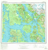
1960 Map of Petersburg
USGS Topo · Published 1970About this map
The maritime crossroads of Southeast Alaska are detailed here in the mid-20th century, revealing the intricate island networks of the Tongass National Forest. The map centers on the major settlements of Petersburg on Mitkof Island and Wrangell on Wrangell Island, positioned strategically along the deep-water channels of the Alexander Archipelago. This era reflects a landscape defined by the salmon and timber industries, where coastal villages like Kake, Hamilton, and the fishing station at Shakan served as vital outposts.
Find a feature on this map
55 named features on this map. Tap any name to fly to it.
Don’t see what you’re looking for? This feature index may not catch every label — zoom into the map to look around manually.
Map Details
Editions of this 1960 Petersburg Map
3 editions found

Other maps of this area

1948 · Sumdum A-4
USGS Topo · 1:63,360

1948 · Port Alexander C-1
USGS Topo · 1:63,360

1948 · Petersburg A-6
USGS Topo · 1:63,360

1948 · Petersburg A-1
USGS Topo · 1:63,360

1948 · Petersburg A-2
USGS Topo · 1:63,360

1948 · Port Alexander A-1
USGS Topo · 1:63,360

1948 · Sumdum A-5
USGS Topo · 1:63,360

1948 · Petersburg C-4
USGS Topo · 1:63,360

1948 · Petersburg B-6
USGS Topo · 1:63,360

1948 · Petersburg C-1
USGS Topo · 1:63,360