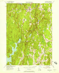
1954 Map of Petersham
USGS Topo · Published 1958About this map
Harvard Forest dominates much of this central Massachusetts landscape, providing a lush backdrop for the historic village of Petersham. At the mid-century, the area remained deeply connected to its agricultural and institutional roots, as evidenced by the Maria Assumpta Academy and numerous family burial grounds like Doubleday Cem and Ledgeville Cem. The map illustrates a significant era of water management, featuring the eastern edge of the Quabbin Reservoir and the subterranean path of the Quabbin Aqueduct. This intersection of protected forestry and large-scale utility infrastructure defines the local geography. Small crossroads settlements like Bassets Corner and the older lanes of Nichewaug are preserved in their post-war state, linked by a network of rural routes including Old Stage Road and Rutland Road.
Find a feature on this map
57 named features on this map. Tap any name to fly to it.
Don’t see what you’re looking for? This feature index may not catch every label — zoom into the map to look around manually.
Map Details
Editions of this 1954 Petersham Map
4 editions found
Other maps of this area

1887 · Warwick
USGS Topo · 1:62,500

1887 · Belchertown
USGS Topo · 1:62,500

1887 · Winchendon
USGS Topo · 1:62,500

1887 · Barre
USGS Topo · 1:62,500

1889 · Barre
USGS Topo · 1:62,500

1889 · Warwick
USGS Topo · 1:62,500

1890 · Belchertown
USGS Topo · 1:62,500

1890 · Winchendon
USGS Topo · 1:62,500

1893 · Belchertown
USGS Topo · 1:62,500

1894 · Winchendon
USGS Topo · 1:62,500