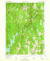
1954 Map of Petersham
USGS Topo · Published 1962About this map
Harvard Forest dominates the northern reaches of this mid-century landscape, surrounding the village of Petersham. This area of Worcester County reflects a period of significant reforestation and land management following the earlier creation of the Quabbin Reservoir, whose eastern waters reach into the southwestern corner of the map near Pottapaug Hill. The village center is home to the Maria Assumpta Academy and several historical burial sites, including the West Street Cem and East Street Cem.
Find a feature on this map
58 named features on this map. Tap any name to fly to it.
Don’t see what you’re looking for? This feature index may not catch every label — zoom into the map to look around manually.
Map Details
Editions of this 1954 Petersham Map
4 editions found
Other maps of this area

1887 · Warwick
USGS Topo · 1:62,500

1887 · Belchertown
USGS Topo · 1:62,500

1887 · Winchendon
USGS Topo · 1:62,500

1887 · Barre
USGS Topo · 1:62,500

1889 · Barre
USGS Topo · 1:62,500

1889 · Warwick
USGS Topo · 1:62,500

1890 · Belchertown
USGS Topo · 1:62,500

1890 · Winchendon
USGS Topo · 1:62,500

1893 · Belchertown
USGS Topo · 1:62,500

1894 · Winchendon
USGS Topo · 1:62,500