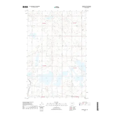
2018 Map of Peterson Lake
USGS Topo · Published 2018About this map
Peterson Lake and the surrounding prairie pothole region of McLean County reveal a landscape defined by glacial depressions and intermittent water. This recent survey illustrates a complex network of wetlands and larger bodies of water such as Lake Williams, Pelican Lake, and Lake Margaret. The terrain is sparsely developed, with a grid of rural section roads like Co Rd 10 and 9th St NW providing access to the interior. Significant for cultural history are the small rural burial grounds, including Medicine Hill Cem, Peace Cem, and Saint Pauls Cem, which often represent the only remaining physical landmarks of early agricultural communities in this part of North Dakota. For recreational interests, the N Country National Scenic Trail winds through the southwestern corner, offering a designated path through the native grasses and wetlands characteristic of the northern plains.
Find a feature on this map
28 named features on this map. Tap any name to fly to it.
Don’t see what you’re looking for? This feature index may not catch every label — zoom into the map to look around manually.
Map Details
Editions of this 2018 Peterson Lake Map
This is the sole edition of this map. No revisions or reprints were ever made.
Other maps of this area

1945 · Pelican Lake
USGS Topo · 1:62,500

1947 · Pelican Lake
USGS Topo · 1:62,500

1947 · Turtle Lake
USGS Topo · 1:62,500

1949 · Turtle Creek
USGS Topo · 1:62,500

1954 · McClusky
USGS Topo · 1:250,000

1958 · McClusky
USGS Topo · 1:250,000

1959 · Mercer
USGS Topo · 1:24,000

1961 · Turtle Lake
USGS Topo · 1:24,000

1961 · Turtle Creek NE
USGS Topo · 1:24,000
1961 · Peterson Lake
USGS Topo · 1:24,000