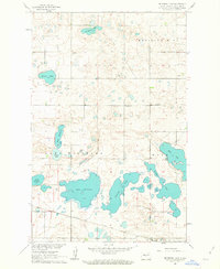
1961 Map of Peterson Lake
USGS Topo · Published 1963About this map
Medicine Hill dominates the northeast corner of this central North Dakota landscape, overlooking a dense concentration of glacial prairie potholes and larger water bodies. The settlement pattern in the early 1960s is defined by a sparse network of section-line roads and the Northern Pacific railroad corridor, which skirts the southern edge of the massive Lake Williams. Rural community life is anchored by scattered landmarks including School No 4 and a series of denominational burial grounds such as Medicine Hill Cem, Peace Cem, and St Pauls Cem. The map reveals an area defined by its hydrology, where large basins like Peterson Lake and Lake Holmes sit alongside smaller named features like Billows Lake and Lake Margaret. Extensive Gravel Pits suggest the importance of local material extraction for maintaining the area's infrastructure and the intermittent Jeep Trail networks that cut across the undulating terrain.
Find a feature on this map
20 named features on this map. Tap any name to fly to it.
Don’t see what you’re looking for? This feature index may not catch every label — zoom into the map to look around manually.
Map Details
Editions of this 1961 Peterson Lake Map
2 editions found
Other maps of this area

1945 · Pelican Lake
USGS Topo · 1:62,500

1947 · Pelican Lake
USGS Topo · 1:62,500

1947 · Turtle Lake
USGS Topo · 1:62,500

1949 · Turtle Creek
USGS Topo · 1:62,500

1954 · McClusky
USGS Topo · 1:250,000

1958 · McClusky
USGS Topo · 1:250,000

1959 · Mercer
USGS Topo · 1:24,000

1961 · Turtle Lake
USGS Topo · 1:24,000

1961 · Turtle Creek NE
USGS Topo · 1:24,000

1961 · Turtle Creek NW
USGS Topo · 1:24,000