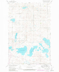
1961 Map of Peterson Lake
USGS Topo · Published 1980About this map
The Missouri River Basin development program shaped the mapping of this North Dakota landscape, characterized by a complex chain of prairie potholes and larger water bodies. Lake Williams and Peterson Lake dominate the central terrain, part of a network that includes Pelican Lake, Blue Lake, and Lake Holmes. These lakes are interspersed with remnants of glacial activity, including several Gravel Pits and the prominent Medicine Hill rise to the northeast.
Find a feature on this map
18 named features on this map. Tap any name to fly to it.
Don’t see what you’re looking for? This feature index may not catch every label — zoom into the map to look around manually.
Map Details
Editions of this 1961 Peterson Lake Map
2 editions found
Other maps of this area

1945 · Pelican Lake
USGS Topo · 1:62,500

1947 · Pelican Lake
USGS Topo · 1:62,500

1947 · Turtle Lake
USGS Topo · 1:62,500

1949 · Turtle Creek
USGS Topo · 1:62,500

1954 · McClusky
USGS Topo · 1:250,000

1958 · McClusky
USGS Topo · 1:250,000

1959 · Mercer
USGS Topo · 1:24,000

1961 · Turtle Lake
USGS Topo · 1:24,000

1961 · Turtle Creek NE
USGS Topo · 1:24,000
1961 · Peterson Lake
USGS Topo · 1:24,000