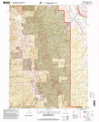
1998 Map of Peterson
USGS Topo · Published 2000About this map
Morgan Valley and the steep slopes of the Wasatch National Forest dominate this landscape during the late 1990s. The settlement of Peterson serves as a focal point near the Weber River, where early local families are memorialized at the Peterson Cem. This area reveals the complex transition from river-valley agriculture to high-elevation forest management, including the Military Springs Reservation and various communication facilities atop prominent summits. High-altitude landmarks like Francis Peak and Nielsons Peak overlook a dense network of drainages such as Hardscrabble Creek and the forks of Peterson Creek. The map also traces established routes for travel and recreation, including the Skyline Drive and the Great Western Trail, which follow the high ridges along the boundary of Morgan and Davis counties.
Find a feature on this map
57 named features on this map. Tap any name to fly to it.
Don’t see what you’re looking for? This feature index may not catch every label — zoom into the map to look around manually.
Map Details
Editions of this 1998 Peterson Map
This is the sole edition of this map. No revisions or reprints were ever made.
Other maps of this area

1885 · Salt Lake
USGS Topo · 1:250,000

1925 · Ft. Douglas
USGS Topo · 1:125,000

1928 · Ft. Douglas
USGS Topo · 1:125,000

1952 · Farmington
USGS Topo · 1:24,000

1952 · Bountiful Peak
USGS Topo · 1:24,000

1954 · Salt Lake City
USGS Topo · 1:250,000

1954 · Ogden
USGS Topo · 1:250,000

1955 · Ogden
USGS Topo · 1:24,000

1955 · Peterson
USGS Topo · 1:24,000

1955 · Kaysville
USGS Topo · 1:24,000