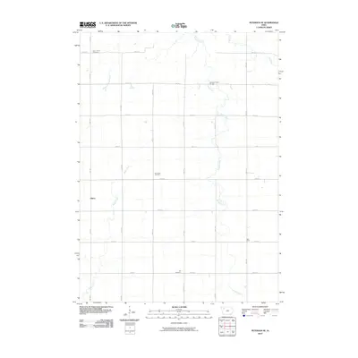
2010 Map of Peterson SE
USGS Topo · Published 2010About this map
Elkton and the crossroads of West Scott anchor this northwestern Iowa landscape, defined by a rigorous grid of section-line roads and the winding paths of rural waterways. The terrain is drained by several prominent streams, including Maple Creek in the southwest and Brooke Creek, which is crossed by the named Brooke Creek Bridge. This 2010 survey highlights the cultural foundations of the area through its local burying grounds, notably Saint John's Cemetery in the north and Elk Cemetery to the south. The layout of the land reflects a traditional Midwestern agricultural pattern, where established family cemeteries like Plainview Cemetery serve as long-standing landmarks amid a network of numbered avenues and streets that facilitate movement through the open country.
Find a feature on this map
27 named features on this map. Tap any name to fly to it.
Don’t see what you’re looking for? This feature index may not catch every label — zoom into the map to look around manually.
Map Details
Editions of this 2010 Peterson SE Map
This is the sole edition of this map. No revisions or reprints were ever made.
Other maps of this area

1954 · Fort Dodge
USGS Topo · 1:250,000

1957 · Fort Dodge
USGS Topo · 1:250,000

1958 · Fort Dodge
USGS Topo · 1:250,000

1969 · Aurelia
USGS Topo · 1:24,000

1971 · Rembrandt
USGS Topo · 1:24,000

1971 · Sioux Rapids
USGS Topo · 1:24,000

1971 · Peterson SW
USGS Topo · 1:24,000

1971 · Peterson SE
USGS Topo · 1:24,000
1971 · Peterson
USGS Topo · 1:24,000
1971 · Sutherland East
USGS Topo · 1:24,000