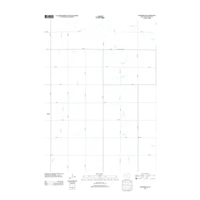
2013 Map of Peterson SE
USGS Topo · Published 2013About this map
Elkton anchors the western edge of this Buena Vista County landscape, where a rigorous grid of section-line roads defines the agrarian layout of Northwest Iowa. The territory is deeply etched by a network of waterways including Brooke Cr and Maple Cr, which carve meandering paths through the steady geometry of the surrounding fields. This 2013 survey illustrates the endurance of the township and range system, with named routes like 20th Ave and 510th St providing the structure for local transit. The map identifies specific infrastructure such as the Brooke Creek Bridge and the location of West Scott, offering a clear view of the rural settlement patterns that have shaped this portion of the Iowa plains over generations.
Find a feature on this map
24 named features on this map. Tap any name to fly to it.
Don’t see what you’re looking for? This feature index may not catch every label — zoom into the map to look around manually.
Map Details
Editions of this 2013 Peterson SE Map
This is the sole edition of this map. No revisions or reprints were ever made.
Other maps of this area

1954 · Fort Dodge
USGS Topo · 1:250,000

1957 · Fort Dodge
USGS Topo · 1:250,000

1958 · Fort Dodge
USGS Topo · 1:250,000

1969 · Aurelia
USGS Topo · 1:24,000

1971 · Rembrandt
USGS Topo · 1:24,000

1971 · Sioux Rapids
USGS Topo · 1:24,000

1971 · Peterson SW
USGS Topo · 1:24,000

1971 · Peterson SE
USGS Topo · 1:24,000
1971 · Peterson
USGS Topo · 1:24,000
1971 · Sutherland East
USGS Topo · 1:24,000