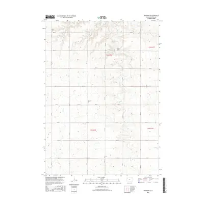
2015 Map of Peterson SE
USGS Topo · Published 2015About this map
Maple Cr and Brooke Cr define the rolling drainage patterns of this Buena Vista County landscape, where agricultural tradition is deeply etched into the section lines. The map reveals a quiet rural layout centered on established family and community sites, most notably Elk Cem in the south and Saint John's Cem to the northwest. This 2015 survey illustrates how the modern road network, including Hwy M27 and Co Hwy M31, follows the precise rectangular grid established during the original land surveys. Genealogists and local researchers will find value in the specific placement of Plainview Cem and the naming of small landmarks like the Brooke Creek Bridge, providing a clear look at the township's structure long after its initial settlement.
Find a feature on this map
27 named features on this map. Tap any name to fly to it.
Don’t see what you’re looking for? This feature index may not catch every label — zoom into the map to look around manually.
Map Details
Editions of this 2015 Peterson SE Map
This is the sole edition of this map. No revisions or reprints were ever made.
Other maps of this area

1954 · Fort Dodge
USGS Topo · 1:250,000

1957 · Fort Dodge
USGS Topo · 1:250,000

1958 · Fort Dodge
USGS Topo · 1:250,000

1969 · Aurelia
USGS Topo · 1:24,000

1971 · Rembrandt
USGS Topo · 1:24,000

1971 · Sioux Rapids
USGS Topo · 1:24,000

1971 · Peterson SW
USGS Topo · 1:24,000

1971 · Peterson SE
USGS Topo · 1:24,000
1971 · Peterson
USGS Topo · 1:24,000
1971 · Sutherland East
USGS Topo · 1:24,000