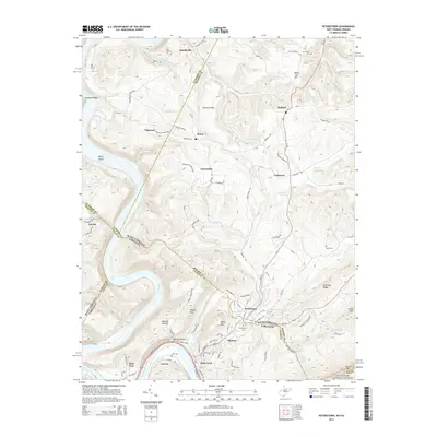
2014 Map of Peterstown
USGS Topo · Published 2014About this map
Peterstown and Rich Creek anchor this survey of the West Virginia-Virginia borderlands, where the New River carves a deep valley between Powell Mtn and Little Mtn. The landscape is defined by its rugged topography and the passage of the Norfolk Southern railway through river-bend settlements like Lurich and Glen Lyn. Genealogists will find several burial grounds across the hills, including Peterstown Cem, Adair Cem, and Mt Carman Cem near the northern border. Cultural landmarks such as Bozoo and Cashmere sit atop the ridges of Chestnut Flats, overlooking the winding courses of Crooked Run and Stinking Lick Cr. To the south, the terrain rises sharply toward the Jefferson National Forest and the heights of Peters Mtn, illustrating the geographical isolation that shaped these mountain communities.
Find a feature on this map
117 named features on this map. Tap any name to fly to it.
Don’t see what you’re looking for? This feature index may not catch every label — zoom into the map to look around manually.
Map Details
Editions of this 2014 Peterstown Map
This is the sole edition of this map. No revisions or reprints were ever made.
Other maps of this area

1887 · Hinton
USGS Topo · 1:125,000

1890 · Dublin
USGS Topo · 1:125,000

1891 · Dublin
USGS Topo · 1:125,000

1892 · Hinton
USGS Topo · 1:125,000

1912 · Big Bend
USGS Topo · 1:62,500

1913 · Peterstown
USGS Topo · 1:48,000

1914 · Big Bend
USGS Topo · 1:62,500

1916 · Peterstown
USGS Topo · 1:62,500

1921 · Alderson
USGS Topo · 1:48,000

1923 · Pearisburg
USGS Topo · 1:62,500