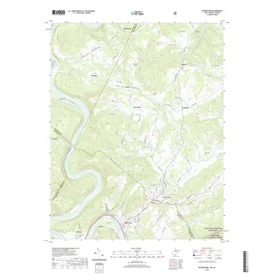
2019 Map of Peterstown
USGS Topo · Published 2019About this map
Peterstown and Rich Creek anchor this survey of the borderlands between Monroe County, West Virginia, and Giles County, Virginia. The New River winds through the western terrain, passing landmarks such as Wylie Island and Wylie Falls, while the Norfolk Southern railway tracks the river's edge through Glen Lyn and Lurich. This area shows a transition from the river-valley industry and transit to the high ridges of the Jefferson National Forest, where the Appalachian National Scenic Trail traverses the southeastern corner. Genealogists and local historians will find numerous family-named landmarks and resting places, including Petelstown Cem, Adair Cem, and Dunn Cem. Settlement patterns follow the winding mountain roads like Shanklins Ferry Rd and Mandeville-Naponset, connecting small communities such as Cashmere, Ballard, and Bozoo.
Find a feature on this map
112 named features on this map. Tap any name to fly to it.
Don’t see what you’re looking for? This feature index may not catch every label — zoom into the map to look around manually.
Map Details
Editions of this 2019 Peterstown Map
This is the sole edition of this map. No revisions or reprints were ever made.
Other maps of this area

1887 · Hinton
USGS Topo · 1:125,000

1890 · Dublin
USGS Topo · 1:125,000

1891 · Dublin
USGS Topo · 1:125,000

1892 · Hinton
USGS Topo · 1:125,000

1912 · Big Bend
USGS Topo · 1:62,500

1913 · Peterstown
USGS Topo · 1:48,000

1914 · Big Bend
USGS Topo · 1:62,500

1916 · Peterstown
USGS Topo · 1:62,500

1921 · Alderson
USGS Topo · 1:48,000

1923 · Pearisburg
USGS Topo · 1:62,500