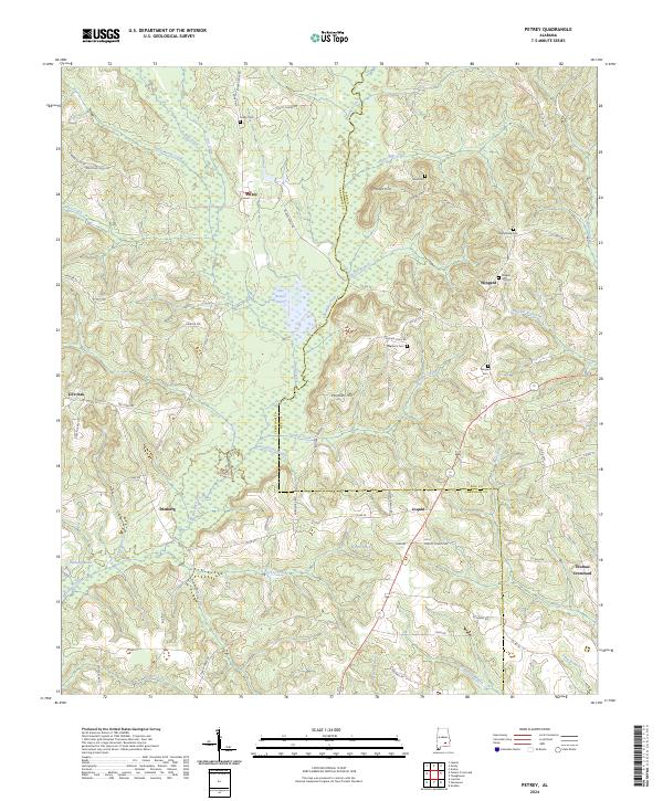
2024 Map of Petrey
USGS Topo · Published 2024About this map
The town of Petrey and the surrounding borderlands of Crenshaw and Pike Counties are defined by a complex network of creeks and small family settlements. Flowing through the center of the sheet, the Patsaliga Creek and its tributaries, such as Piney Woods Creek and Turkey Creek, dictate the placement of early homesteads and cemeteries. Significant genealogical markers include Petrey Cem and Wingard Cem, which sit near clusters of development at Wingard and Live Oak. The landscape transitions from the higher elevations of Motes Hill in the north toward the marshy lowlands of The Beaver Pond and Byrds Pond in the south. This area, largely agricultural and timber-focused, is knit together by historic routes like Lapine Hwy and Shady Grove Rd, connecting rural outposts like Joquin and Patsburg to the larger county infrastructure.
Find a feature on this map
86 named features on this map. Tap any name to fly to it.
Don’t see what you’re looking for? This feature index may not catch every label — zoom into the map to look around manually.
Map Details
Editions of this 2024 Petrey Map
This is the sole edition of this map. No revisions or reprints were ever made.
Other maps of this area

1953 · Andalusia
USGS Topo · 1:250,000

1957 · Andalusia
USGS Topo · 1:250,000
1968 · Goshen
USGS Topo · 1:24,000
1968 · Youngblood
USGS Topo · 1:24,000

1968 · Glenwood
USGS Topo · 1:24,000
1968 · Ansley
USGS Topo · 1:24,000

1968 · Petrey
USGS Topo · 1:24,000

1968 · Grady
USGS Topo · 1:24,000

1971 · Luverne
USGS Topo · 1:24,000

1971 · Fullers Crossroads
USGS Topo · 1:24,000