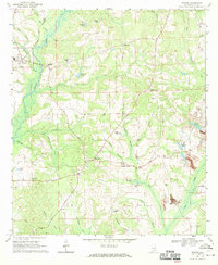
1968 Map of Goshen
USGS Topo · Published 1970About this map
The Conecuh River defines the western landscape of this Pike County region, where the town of Goshen sits near the confluence of Howard Creek and Elam Branch. During the late 1960s, this area supported a network of small agricultural and timber communities connected by rural schools and churches, such as Stringer High Sch and Bethel Ch. The terrain transitions from the river bottomlands to higher ground at Sanders Hill, where a Lookout Tower once overlooked the surrounding timber stands.
Find a feature on this map
48 named features on this map. Tap any name to fly to it.
Don’t see what you’re looking for? This feature index may not catch every label — zoom into the map to look around manually.
Map Details
Editions of this 1968 Goshen Map
2 editions found
Other maps of this area

1948 · Brundidge
USGS Topo · 1:62,500

1950 · Brundidge
USGS Topo · 1:62,500

1953 · Andalusia
USGS Topo · 1:250,000

1953 · Dothan
USGS Topo · 1:250,000

1954 · Dothan
USGS Topo · 1:250,000

1955 · Dothan
USGS Topo · 1:250,000

1957 · Andalusia
USGS Topo · 1:250,000

1960 · Victoria
USGS Topo · 1:24,000

1960 · Brundidge NW
USGS Topo · 1:24,000
1962 · Victoria
USGS Topo · 1:25,000