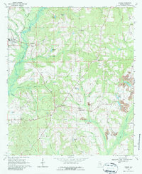
1968 Map of Goshen
USGS Topo · Published 1987About this map
Goshen serves as a primary hub in this Pike County landscape, situated along the Central of Georgia rail line. The late 1960s rural character of the region is defined by a network of small settlements like Henderson, Pleasant Ridge, and Baltic, many centered around local institutions such as Stringer High Sch and Hopewell Ch. The terrain is deeply carved by the Conecuh River and its numerous tributaries, including Smilies Mill Creek and Warrick Creek.
Find a feature on this map
55 named features on this map. Tap any name to fly to it.
Don’t see what you’re looking for? This feature index may not catch every label — zoom into the map to look around manually.
Map Details
Editions of this 1968 Goshen Map
2 editions found
Other maps of this area

1948 · Brundidge
USGS Topo · 1:62,500

1950 · Brundidge
USGS Topo · 1:62,500

1953 · Andalusia
USGS Topo · 1:250,000

1953 · Dothan
USGS Topo · 1:250,000

1954 · Dothan
USGS Topo · 1:250,000

1955 · Dothan
USGS Topo · 1:250,000

1957 · Andalusia
USGS Topo · 1:250,000

1960 · Victoria
USGS Topo · 1:24,000

1960 · Brundidge NW
USGS Topo · 1:24,000
1962 · Victoria
USGS Topo · 1:25,000