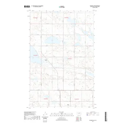
2017 Map of Petrified Lake
USGS Topo · Published 2017About this map
Petrified Lake and Round Lake lie at the heart of this Pierce County landscape, surrounded by a complex system of glacial wetlands and prairie potholes. The terrain is defined by low-lying basins and the prominent Buffalo Coulee, which cuts a distinct path through the central portion of the area. This 2017 survey reveals the strictly organized township and range grid that continues to dictate human movement in the region, with north-south roads like 32nd Ave NE and east-west routes such as 44th St NE providing the primary access to the isolated farmsteads and agricultural plots. In the southern reach of the quadrangle, the Ripplinger Strip indicates localized land use patterns or family-named features often found in rural North Dakota. Large water bodies like Girard Lake and Long Lake punctuate the northern and western margins, serving as vital topographical landmarks in an otherwise subtle, rolling environment.
Find a feature on this map
26 named features on this map. Tap any name to fly to it.
Don’t see what you’re looking for? This feature index may not catch every label — zoom into the map to look around manually.
Map Details
Editions of this 2017 Petrified Lake Map
This is the sole edition of this map. No revisions or reprints were ever made.
Other maps of this area

1940 · Aylmer
USGS Topo · 1:62,500

1941 · Selz
USGS Topo · 1:62,500

1951 · Selz NE
USGS Topo · 1:24,000

1951 · Selz NW
USGS Topo · 1:24,000

1952 · New Rockford
USGS Topo · 1:250,000

1953 · Devils Lake
USGS Topo · 1:250,000

1954 · Minot
USGS Topo · 1:250,000

1954 · McClusky
USGS Topo · 1:250,000

1956 · New Rockford
USGS Topo · 1:250,000

1956 · Devils Lake
USGS Topo · 1:250,000