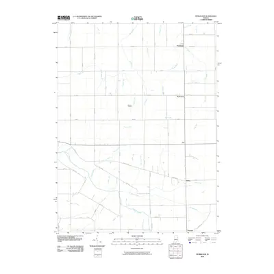
2010 Map of Petroleum
USGS Topo · Published 2010About this map
Petroleum and Nottingham anchor the northern reaches of this rural landscape, which is defined by a dense network of agricultural drainage and small waterways. The Salamonie River meanders across the southern half, joined by numerous tributaries including Stoney Creek, Beaver Creek, and Haines Creek. This 2010 survey illustrates a highly organized grid of county roads that connects small settlements like Fiat and Balbec with the more established Pennville near the southern boundary.
Find a feature on this map
54 named features on this map. Tap any name to fly to it.
Don’t see what you’re looking for? This feature index may not catch every label — zoom into the map to look around manually.
Map Details
Editions of this 2010 Petroleum Map
This is the sole edition of this map. No revisions or reprints were ever made.
Other maps of this area

1953 · Muncie
USGS Topo · 1:250,000

1956 · Muncie
USGS Topo · 1:250,000

1960 · Pennville
USGS Topo · 1:24,000

1960 · Hartford City East
USGS Topo · 1:24,000

1960 · Blaine
USGS Topo · 1:24,000

1962 · Montpelier
USGS Topo · 1:24,000

1962 · Liberty Center
USGS Topo · 1:24,000

1962 · Petroleum
USGS Topo · 1:24,000

1962 · Linn Grove
USGS Topo · 1:24,000
1962 · Domestic
USGS Topo · 1:24,000