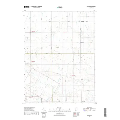
2019 Map of Petroleum
USGS Topo · Published 2019About this map
The Salamonie River meanders across the southern half of this landscape, forming a natural boundary near the border of Blackford County and Jay County. This area of eastern Indiana is defined by a dense network of water management features, including the McClain Ditch, Sharpe Ditch, and Maddux-Showalter Ditch, which support the surrounding agricultural lands. Small rural settlements like Petroleum, Nottingham, Fiat, and Balbec are dispersed throughout the region, often centered on historic road junctions such as W State Rd 18. Near the northern edge of the map, the town of Petroleum serves as a local hub, while the Bloxsom Cem provides a tangible link to the area's early residents. Further south, the town of Pennville anchors the corner of the survey near Haines Cr, illustrating the long-standing relationship between local settlements and the regional drainage basins of the Beaver Creek and Mill Creek.
Find a feature on this map
70 named features on this map. Tap any name to fly to it.
Don’t see what you’re looking for? This feature index may not catch every label — zoom into the map to look around manually.
Map Details
Editions of this 2019 Petroleum Map
This is the sole edition of this map. No revisions or reprints were ever made.
Other maps of this area

1953 · Muncie
USGS Topo · 1:250,000

1956 · Muncie
USGS Topo · 1:250,000

1960 · Pennville
USGS Topo · 1:24,000

1960 · Hartford City East
USGS Topo · 1:24,000

1960 · Blaine
USGS Topo · 1:24,000

1962 · Montpelier
USGS Topo · 1:24,000

1962 · Liberty Center
USGS Topo · 1:24,000

1962 · Petroleum
USGS Topo · 1:24,000

1962 · Linn Grove
USGS Topo · 1:24,000
1962 · Domestic
USGS Topo · 1:24,000