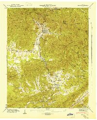
1946 Map of Petros
USGS Topo · Published 1947About this map
Brushy Mountain State Prison sits at the head of a narrow valley, surrounded by the steep ridges of Frozen Head State Forest and Brushy Mountain. This 1940s topography illustrates the isolated industrial and institutional character of the Petros area, where the Southern railroad line terminates and an Abandoned Incline remains on the slopes above the prison. The landscape transitions from the high peaks of Frozen Head Mountain and Whetstone Mountain in the west toward the agricultural and mining communities of Stephens and Coalfield to the south. Small family and community landmarks, including Brassel Cem and Joyner Sch, are scattered throughout the hollows. The presence of Coalfield Camp No 1 and Coalfield Camp No 2 reflects the period's coal-driven economy, with numerous roads and trails following the drainage of Crooked Fork and Emory River through the gaps.
Find a feature on this map
92 named features on this map. Tap any name to fly to it.
Don’t see what you’re looking for? This feature index may not catch every label — zoom into the map to look around manually.
Map Details
Editions of this 1946 Petros Map
2 editions found
Other maps of this area

1887 · Kingston
USGS Topo · 1:125,000

1891 · Kingston
USGS Topo · 1:125,000

1893 · Briceville
USGS Topo · 1:125,000

1893 · Kingston
USGS Topo · 1:125,000

1895 · Wartburg
USGS Topo · 1:125,000

1895 · Loudon
USGS Topo · 1:125,000

1895 · Briceville
USGS Topo · 1:125,000

1896 · Wartburg
USGS Topo · 1:125,000

1896 · Briceville
USGS Topo · 1:125,000

1935 · Gobey
USGS Topo · 1:24,000