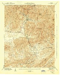
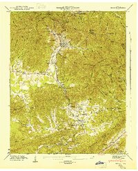
1946 Map of Petros
USGS Topo · Published 1947About this map
Brushy Mountain State Prison sits at the head of a narrow valley, illustrating the isolated geography of the Cumberland Plateau in the years following World War II. The settlement of Petros serves as the focal point for this rugged terrain, where the extraction of natural resources is evident in the presence of Coalfield Camp No 1 and Coalfield Camp No 2. This era shows a landscape transitioning between remote wilderness and industrial labor, with the Southern RR skirting the southern ridges while steep topography like Frozen Head Mountain remains largely undeveloped.
Find a feature on this map
95 named features on this map. Tap any name to fly to it.
Don’t see what you’re looking for? This feature index may not catch every label — zoom into the map to look around manually.
Map Details
Editions of this 1946 Petros Map
2 editions found
Other maps of this area

1887 · Kingston
USGS Topo · 1:125,000

1891 · Kingston
USGS Topo · 1:125,000

1893 · Briceville
USGS Topo · 1:125,000

1893 · Kingston
USGS Topo · 1:125,000

1895 · Wartburg
USGS Topo · 1:125,000

1895 · Loudon
USGS Topo · 1:125,000

1895 · Briceville
USGS Topo · 1:125,000

1896 · Wartburg
USGS Topo · 1:125,000

1896 · Briceville
USGS Topo · 1:125,000

1935 · Gobey
USGS Topo · 1:24,000