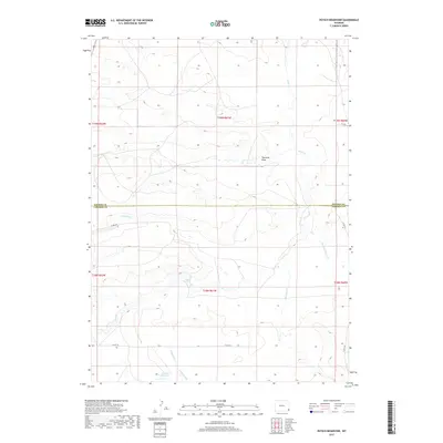
2017 Map of Petsch Reservoir
USGS Topo · Published 2017About this map
Horse Cr dominates the drainage patterns across this high plains borderland, where the boundary between Goshen Co and Laramie Co divides the landscape. This 2017 survey shows an area defined by carefully managed water resources and a rural road network, including Co RD 236 and Co RD 6. The southern portion of the quadrangle features the Petsch Reservoir, fed by the distinct branches of Kellehan Cr and E Kellehan Cr. The presence of the Coad Ditch in the northwest and naming of seasonal watercourses like Fourmile Draw and Stinking Water Cr reflect the vital importance of irrigation and watershed management in this Wyoming interior. The map clearly delineates the Public Land Survey System grids, showing the townships from T18N to T19N and ranges from R60W to R62W, providing a precise spatial framework for land ownership and historical research.
Find a feature on this map
19 named features on this map. Tap any name to fly to it.
Don’t see what you’re looking for? This feature index may not catch every label — zoom into the map to look around manually.
Map Details
Editions of this 2017 Petsch Reservoir Map
This is the sole edition of this map. No revisions or reprints were ever made.
Other maps of this area

1899 · Goshen Hole
USGS Topo · 1:125,000

1954 · Cheyenne
USGS Topo · 1:250,000

1958 · Cheyenne
USGS Topo · 1:250,000

1960 · Tremain
USGS Topo · 1:24,000

1960 · Mc Compsey Pass
USGS Topo · 1:24,000

1960 · Petsch Reservoir
USGS Topo · 1:24,000

1960 · Kessler Gap
USGS Topo · 1:24,000

1960 · Meriden
USGS Topo · 1:24,000

1960 · La Grange
USGS Topo · 1:24,000
1963 · Round Top
USGS Topo · 1:24,000