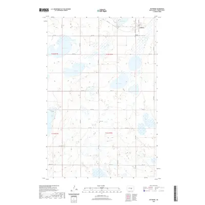
2020 Map of Pettibone
USGS Topo · Published 2020About this map
Pettibone occupies the northeastern corner of this Kidder County landscape, serving as a concentrated hub of settlement within a sprawling grid of agricultural sections. The town's local history is anchored by the Bethlehem Cem located just to the south, while the Weiser Cem sits further afield in the central plains. This 2020 data reveals a terrain heavily defined by its prairie potholes and seasonal basins, where bodies of water like South Lake, Bond Lake, and Ranch Lake are interspersed among unnamed wetlands. The rectangular road network, featuring routes such as 44th Ave SE and 25th St SE, maintains a rigid order over a landscape where drainage is dominated by natural depressions like Brock Slough and Kunkel Lake.
Find a feature on this map
28 named features on this map. Tap any name to fly to it.
Don’t see what you’re looking for? This feature index may not catch every label — zoom into the map to look around manually.
Map Details
Editions of this 2020 Pettibone Map
This is the sole edition of this map. No revisions or reprints were ever made.
Other maps of this area

1952 · Tappen NE
USGS Topo · 1:24,000

1952 · Tappen North
USGS Topo · 1:24,000

1952 · New Rockford
USGS Topo · 1:250,000

1953 · Jamestown
USGS Topo · 1:250,000

1955 · Crystal Springs
USGS Topo · 1:24,000

1956 · New Rockford
USGS Topo · 1:250,000

1956 · Jamestown
USGS Topo · 1:250,000

1971 · New Rockford
USGS Topo · 1:250,000

1972 · Kunkel Lake
USGS Topo · 1:24,000
1972 · Lake Louise
USGS Topo · 1:24,000