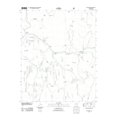
2011 Map of Pettigrew
USGS Topo · Published 2011About this map
Pettigrew and Dutton serve as the primary hubs in this corner of the Ozark National Forest, where the White River and its various tributaries have carved deep valleys through the plateau. The settlement pattern is defined by these waterways, with the East Prong White River and Baldwin Creek creating distinct hollows and ridges like Sailor Ridge and Watson Ridge. Genealogy researchers will find significant value in the numerous family-named landmarks and burial grounds scattered across the terrain, including Williams Cemetery, Liberty Cemetery, and Adkins Cemetery. The map also captures the local infrastructure of the early 21st century, from the Pettigrew Post Office to a network of forest roads and county routes that navigate steep gaps such as Kilgore Gap and Mitchell Gap.
Find a feature on this map
54 named features on this map. Tap any name to fly to it.
Don’t see what you’re looking for? This feature index may not catch every label — zoom into the map to look around manually.
Map Details
Editions of this 2011 Pettigrew Map
This is the sole edition of this map. No revisions or reprints were ever made.
Other maps of this area

1879 · Cravens
USGS Topo · 1:62,500

1887 · Watalula
USGS Topo · 1:62,500

1906 · Batson
USGS Topo · 1:62,500

1939 · Watalula
USGS Topo · 1:62,500

1943 · St. Paul
USGS Topo · 1:62,500

1946 · St. Paul
USGS Topo · 1:62,500

1956 · Russellville
USGS Topo · 1:250,000

1964 · Russellville
USGS Topo · 1:250,000
1973 · Witter
USGS Topo · 1:24,000
1973 · Boston
USGS Topo · 1:24,000